18 thoughts on “Category 5 Hurricane Patricia about a day from landfall in SW Mexico”
Supposed to weaken to a Category 4 by landfall but at that point the damage won't be much different. This is likely to be one of the worst hurricanes to ever hit that area, and probably magnified by the incredible rate of intensification. It was a tropical storm last night, and people were expecting a 2 at that point.
Yes. I hope their version of FEMA is on the ball. It's no fun at all looking down the barrel of one of these things even when you've got the full array of information sources the 21st century can provide. I bet all the fisher people that live by reading the sea and weather have seen the signs and are fully battened down.
Certainly looks like it, it's just a bit northwest of the latest track. Still in the cone and under a hurricane warning, so I'd be getting out of there if possible if I lived there.
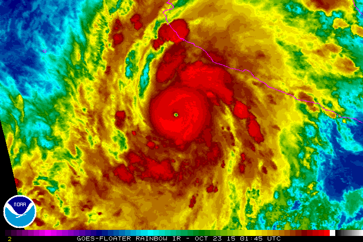
I hope they got a dropsonde down in the plane because the readings are kind of suspect right at the worst time but extrapolated pressure of 890.9 mb and flight-level wind of 206 mph (would be approximately 185 mph at the surface). Kind of suspicious of that kind of number but we'll likely get more data about that in the next half hour at the latest.
Wasn't going to mention it since it's long-range but it's certainly a possibility. Some keep a high pressure in CA that's just strong enough to keep it away, but it's worth watching.
Supposed to weaken to a Category 4 by landfall but at that point the damage won't be much different. This is likely to be one of the worst hurricanes to ever hit that area, and probably magnified by the incredible rate of intensification. It was a tropical storm last night, and people were expecting a 2 at that point.
Well, that blew up quickly. As they do.
I hope everyone in the max storm surge area beats feet, and quick.
This was one of the fastest blow-ups of all time. Hopefully the message got out quickly enough for everyone to get out of there.
Yes. I hope their version of FEMA is on the ball. It's no fun at all looking down the barrel of one of these things even when you've got the full array of information sources the 21st century can provide. I bet all the fisher people that live by reading the sea and weather have seen the signs and are fully battened down.
That looks like it will throw more rain into AZ next week
Actually, it looks likely that the moisture will head northeast into Texas for this one.
yeah, now that I've gotten a look at the track on something besides my phone… BTW 200mph now, holy shit!
I suspect one of these is gonna WHOMP us this winter. It's nice now, but this wet OCT. is looking familiar…..
Holeeeeeeeeeeee FUCK!
Hard to tell from the maps but it looks like Puerto Vallarta is right on the likliest path.
Certainly looks like it, it's just a bit northwest of the latest track. Still in the cone and under a hurricane warning, so I'd be getting out of there if possible if I lived there.
Dennis Mersereau is on it.
It's really going to be Bad.
Yeah, that article sums it up. Seems like there's some shitty comments, but the guy is firing back at the bad ones quite nicely.
Dennis is particularly effective with the trolls, but, oh yeah, don't read the comments.
Cat 5. Oh, shit.
I hope they got a dropsonde down in the plane because the readings are kind of suspect right at the worst time but extrapolated pressure of 890.9 mb and flight-level wind of 206 mph (would be approximately 185 mph at the surface). Kind of suspicious of that kind of number but we'll likely get more data about that in the next half hour at the latest.
Update: Dropsonde hit at 894 mb with 25 kt wind. Probably going to be 892 adjusted, which is a new record for the East Pacific. Unreal.
Edit: Vortex fix 894 mb, 168 mph confirmed surface wind, 206 mph flight-level (which means highest winds might be higher than 168 at the surface)
Wasn't going to mention it since it's long-range but it's certainly a possibility. Some keep a high pressure in CA that's just strong enough to keep it away, but it's worth watching.
Hope your niece is paying attention. At the very least it'll be a flooding event. Good luck with everything there.