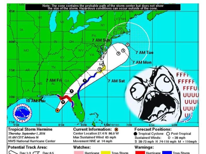
2. Hermine is expected to undergo a complex interaction with a
frontal system when it reaches the Carolinas over the weekend. It
is a little early to say what the specific impacts will be for the
mid-Atlantic and northeastern states.
I went to FL in 2005, and everywhere I went on the Gulf Coast was tragic evidence of Ivan. They hadn't had a chance to clear that damage before the 2005 season hit.
I can't keep up with the locales of all the wonkvillains. I'm on the east side of the Sierra for the moment, going to NV on Sunday for a few days. I feel like a ping pong ball sometimes.
Nope, didn't feel a thing! The big'n off the coast of the North Island, right?
It's difficult, especially since some members of the Wonkville Area of Operations have switched locations. (I remain in the Pasadena, San Gabriel valley sector.)
I spent a few months in Glendale when I was working in Pasadena a lifetime ago. It was nice, 45 years ago. I was back in Glendale in 2014 on a medical tourism trip. I miss the Socialists of yore.
It's strengthened significantly" to the east (as of the 1200 bulletin, which I can't imbed fro some reason ), and the TS watches/warnings have been extended I think it's going to bring a lot of water down, hurricane force or not.
1200: Reports from a hurricane hunter aircraft indicate that
the extent of tropical-storm-force winds has increased
significantly in the eastern semicircle. This requires an
extension of the tropical storm warning southward along both
Florida coasts. This Special Advisory is being issued to modify
the warnings, and to update the analyzed and forecast wind radii.
The most important consideration here is that broadcasters need to remember that "Hermine" was the sexually ambiguous character in Steppenwolf who lead Harry Haller on his journey of discovery and weirdness, and that the name is pronounced HAIR-me-nuh, not her-MEAN.
Good news for those of you in the northeast, though. You'll get full cyclone advisories and warnings even after it becomes non-tropical.
2. Hermine is expected to become a post-tropical cyclone while still
producing hazardous winds and storm surge over land. NWS policy
allows NHC to write advisories on and issue tropical storm
watches and warnings for post-tropical cyclones, when the system
continues to pose a significant threat to life and property.
NHC and the NWS Eastern Region have decided that this option will be
invoked for Hermine. After Hermine becomes a post-tropical cyclone,
NHC will continue to issue its full suite of advisory and warning
products for as long as the system remains a significant threat to
land.
FFFFUUUU, etc.
<img src="https://img.washingtonpost.com/blogs/capital-weather-gang/files/2016/08/Capture-euro-new.png&w=1484"/>
You know who else is a European model?
General Motors?
<img src="http://bestcarmag.com/sites/default/files/3769722opel-manta-a-2.jpg"/>
I prefer:
<img src="http://www.lewisdesoto.net/Opel_GT_for_sale/OPEL_GT_FOR_SALE_files/shapeimage_1.png"</img>
*sploosh*
2. Hermine is expected to undergo a complex interaction with a
frontal system when it reaches the Carolinas over the weekend. It
is a little early to say what the specific impacts will be for the
mid-Atlantic and northeastern states.
I'm planning on getting hit with rain bands on Saturday, at least.
Yeah, that seems safe. Low-confidence forecast though.
My friends on Sanibel and Captiva Islands have been eerily silent of late.
Man, I hope they have an evac plan because they might need it. Hopefully they're just prepping.
There hasn't actually been a hurricane landfall in Florida since 2005. Can Hermine get to that strength? It'll be close.
I went to FL in 2005, and everywhere I went on the Gulf Coast was tragic evidence of Ivan. They hadn't had a chance to clear that damage before the 2005 season hit.
I'll still take my earthquakes.
I'm in Ohio so I get neither, yay!
Yeah, but you've got a Drumpf Squall there today.
Don't jinx us, man!
I won't be returning, if that's any comfort.
To FL? I'm out here in quake country with you!
Whoa! Did you feel that?
I can't keep up with the locales of all the wonkvillains. I'm on the east side of the Sierra for the moment, going to NV on Sunday for a few days. I feel like a ping pong ball sometimes.
Nope, didn't feel a thing! The big'n off the coast of the North Island, right?
It's difficult, especially since some members of the Wonkville Area of Operations have switched locations. (I remain in the Pasadena, San Gabriel valley sector.)
I spent a few months in Glendale when I was working in Pasadena a lifetime ago. It was nice, 45 years ago. I was back in Glendale in 2014 on a medical tourism trip. I miss the Socialists of yore.
It's strengthened significantly" to the east (as of the 1200 bulletin, which I can't imbed fro some reason ), and the TS watches/warnings have been extended I think it's going to bring a lot of water down, hurricane force or not.
1200:
Reports from a hurricane hunter aircraft indicate that
the extent of tropical-storm-force winds has increased
significantly in the eastern semicircle. This requires an
extension of the tropical storm warning southward along both
Florida coasts. This Special Advisory is being issued to modify
the warnings, and to update the analyzed and forecast wind radii.
Florida's going to be hit with a Cincinnati of rain.
Crikey! Stay safe friends!
GIANT RAINBOW KITE STALLS OVER SOUTHERN CHESAPEAKE
ENORMOUS CHILD CAUSES CHAOS, TRAFFIC JAMS RETRIEVING IT
<img src="https://images-na.ssl-images-amazon.com/images/I/614WtzYAH1L._SY355_.jpg"/>
<img src="http://news.xinhuanet.com/english/photo/2015-10/17/134723064_1390850111n.jpg" />
<img src="https://kitelife.com/wp-content/uploads/2012/03/9561-Relaxed-And-Flying-We.jpg"/>
The most important consideration here is that broadcasters need to remember that "Hermine" was the sexually ambiguous character in Steppenwolf who lead Harry Haller on his journey of discovery and weirdness, and that the name is pronounced HAIR-me-nuh, not her-MEAN.
http://www.nhc.noaa.gov/pdf/aboutnames_pronounce_…
Nah the broadcasters are right
I mean, she mean!
Hermine's a hurricane now, Florida's streak looks to end tonight.
Good news for those of you in the northeast, though. You'll get full cyclone advisories and warnings even after it becomes non-tropical.
2. Hermine is expected to become a post-tropical cyclone while still
producing hazardous winds and storm surge over land. NWS policy
allows NHC to write advisories on and issue tropical storm
watches and warnings for post-tropical cyclones, when the system
continues to pose a significant threat to life and property.
NHC and the NWS Eastern Region have decided that this option will be
invoked for Hermine. After Hermine becomes a post-tropical cyclone,
NHC will continue to issue its full suite of advisory and warning
products for as long as the system remains a significant threat to
land.
In preparation for the deluge, the thing to do is make a tambourine out of an old bamboo steamer and steel cans.