197 thoughts on “Hurricane Matthew strengthening again; strongest hurricane to affect area in living memory”
I don't think we have anyone in the area but this storm's so dangerous that I'm making this a sticky. Category 4 in a place that hasn't had a major hurricane since… I don't even know when, but it was way before I was born. I'll check on that.
If Matthew keeps on the predicted track, though, it will roll over the |||||| Kennedy Space Center Complex | as a Cat 4 or 5. For the KSC and all the towns on the upper Florida coast, this is catastrophic.
Just like Christie, Scott looks at government as a trough for his friends and a hammer to his enemies. Any benefit to his constituents is an after thought, unless he gets some direct benefit.
They get their constiuents all riled up about how terrible "liberals" are, but California is arguably the most progressive state in the nation, the most populous, with high working poor, high minority and undocumented populations, high taxes, incredible social welfare programs that even reach strongly into the middle class and that even I benefit directly from, and yet somehow California is also the most prosperous state in the nation. If it were a sovereign state we'd have something like the fifth or sixth largest economy in the world.
Our attorney general aggressively goes after corporate grift (and she's probably going to be our next senator), and somehow people don't scream that she's hurting job creators.
I wish people in Florida would wake up and start voting in their own interests.
You can bet Gov. Bat Boy won't get caught hugging Obama, though. He's learned from Christie's mistake.
He was acting like Obama was trying to hurt Florida in his morning press conference.
Ugh. I'm probably happy I didn't see that.
Homestead might get tropical storm winds, but cat 4 in east-central Florida looks likely which is terrifying.
Very. Even though the winds will be less on the left upper quadrant of the storm, the storm surge and torrential rain flooding will be awful and the damage could be nearly total. I saw firsthand the devastation Sandy caused and that was a Category 1 at landfall. I'm afraid to even look at the tide predictions, because if thing hits at high tide all is lost.
And a tiny shift left in the track brings the worst onshore. Even the left side is probably going to be cat 3 winds in the eyewall though. They're also talking like 6-9 feet of storm surge too.
The surge is what will wipe you out. Matthew's so large that even if it does stay offshore there will be widespread damage along most of the central coast.
I've got old friends in Boynton Beach FL and Hilton Head SC that have been evacuated. The ones in Hilton Head left CA years ago because they feared earthquakes. Go figure.
Anytime anybody in the US complains about how tough their life is, remind them that they are not Haitian. Those people have had nothing but awful things happening.
There was a story a few years ago of post-earthquake protests in Haiti and that the protesters were so poor that the only incendiaries they could throw was lighted poo.
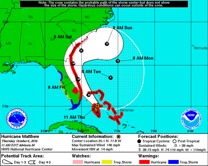
SUMMARY OF 1200 PM EDT…1600 UTC…INFORMATION
———————————————–
LOCATION…25.3N 78.0W
ABOUT 45 MI…70 KM WNW OF NASSAU BAHAMAS
ABOUT 160 MI…260 KM SE OF WEST PALM BEACH
MAXIMUM SUSTAINED WINDS…140 MPH…220 KM/H
PRESENT MOVEMENT…NW OR 325 DEGREES AT 14 MPH…22 KM/H
MINIMUM CENTRAL PRESSURE…940 MB…27.76 INCHES
Other buoy station to the north have the water temp. at 84 F. With no real upper level wind shear, that much energy in the ocean and nothing to hit, this hurricane staying at Cat 4 is probably the best scenario.
Andrew Bieszad, a contributor to Shoebat.com, the website run by anti-gay extremists Walid and Theodore Shoebat, has some thoughts about Hurricane Matthew, which is expected to strike the East Coast of the United States in the coming days: "Hurricane Matthew Is The Wrath Of God Poured Out On The Cities Of Orlando And Savannah For Supporting The Evil Sodomites."
God is sending this hurricane, Bieszad states, as "a sign of His anger" against America for tolerating homosexuality and to thwart a gay pride festival scheduled to take place in Orlando this weekend.
"You want to stop not this hurricane, but future catastrophes?" he asks. "Then stop sinning, especially with sodomy":
OK, so the Human Race invented warfare, pogroms, genocide, weapons capable of sterilizing the planet and widespread environmental destruction and it's Sodomy that really pisses God off.
I don't think you're reading that Book of yours right.
I was in Washington, D.C. during Isabel and sometime in the middle of the storm I woke up, thought, ooh, I should see what it's like outside, so I opened the front door, and it felt like being blasted with tiny needles, which I assume was the raindrops being blown sideways at more than a hundred miles per hour.
(Closed the door super fast.)
I have hiked in 70 mph winds on Mt Washington in NH, and felt 100 mph gusts. There is no way I could hike in anything stronger than about 70 mph- especially since at that speed it's typically gusty and you expend way too much energy just maintaining your balance. Snow flurries felt like I was being sandblasted. Add to that faster winds, and the debris? Anyone who says that's not a problem is not taking their medication.
Am I the only person left on earth that managed to be on the top of Mt Washington with sunny skies and <10 mph winds?
Once in the summer I was up there and it was about 55F with light winds. Another time, climbing up 4th of July weekend, it was 29F, 80 mph winds and snowing at the top. We didn't summit that day. Rain/snow line was right at the headwall of the ravines, nasty.
I've never even been to NH. I need to rectify that.
Lucky you could.
Riding a motorcycle at high speeds is challenging too, and you've even got something to hang on to!
Inflow from the SW and should get better once it passes that island. Wouldn't be surprised if the eye got more obvious than it currently is in a few hours.
An automated station in the Berry Islands, Bahamas, reported a
sustained wind of 59 mph (95 km/h), with gusts to 76 mph (120
km/h) during the past hour.
SUMMARY OF 100 PM EDT…1700 UTC…INFORMATION
———————————————–
LOCATION…25.5N 78.2W
ABOUT 80 MI…125 KM SSE OF FREEPORT BAHAMAS
ABOUT 145 MI…230 KM SE OF WEST PALM BEACH
MAXIMUM SUSTAINED WINDS…140 MPH…220 KM/H
PRESENT MOVEMENT…NW OR 325 DEGREES AT 14 MPH…22 KM/H
MINIMUM CENTRAL PRESSURE…940 MB…27.76 INCHES
Station SBGF1 (Little Bahama)
NDBC
Location: 26.704N 78.995W
Date: Thu, 6 Oct 2016 17:00:00 UTC
Winds: NE (40°) at 36.9 kt gusting to 41.0 kt
Atmospheric Pressure: 29.58 in and falling rapidly
Air Temperature: 77.5 F
Dew Point: 73.9 F
That's 42 and 47 mph, respectively. Widespread power outages are only the beginning.
BULLETIN
HURRICANE MATTHEW INTERMEDIATE ADVISORY NUMBER 34A
NWS NATIONAL HURRICANE CENTER MIAMI FL AL142016
200 PM EDT THU OCT 06 2016
…HURRICANE MATTHEW RELENTLESSLY POUNDING THE BAHAMAS…
…POTENTIALLY DISASTROUS IMPACTS FOR FLORIDA…
SUMMARY OF 200 PM EDT…1800 UTC…INFORMATION
———————————————-
LOCATION…25.7N 78.4W
ABOUT 65 MI…100 KM SSE OF NASSAU
ABOUT 125 MI…205 KM ESE OF WEST PALM BEACH FLORIDA
MAXIMUM SUSTAINED WINDS…140 MPH…220 KM/H
PRESENT MOVEMENT…NW OR 325 DEGREES AT 14 MPH…22 KM/H
MINIMUM CENTRAL PRESSURE…939 MB…27.73 INCHES
1292. Nolehead
5:59 PM GMT on October 06, 2016
i know everyone will think i'm crazy but hear me out, what if the govt is going to use HARRP to deflect the system? i mean the H hunter leaves with whatever problem it had, now satellites are down?? just could be a coincidence but nothing would surprise me anymore.
Heard from my friend Louie in Melbourne, he is driving north through Georgia right now with the wife and kids, no hotels with vacancy. I sent an email to BadKitty, he's in St Augustine…
Oh boy, BK's probably hunkered down in an evac shelter now. Hope he's got WiFi.
I ran from Bob like that: straight across Maine, NH and VT – no hotel rooms, torrential rain bands 2 lane highway, endless RV's. Just had to keep driving. Fun.
Matthew can be seen on Miami radar now. Very clear double eyewall structure. That would normally mean a slight weakening of the winds over the next 12-24 hours, but that also means a much wider hurricane-force windfield.
HURRICANE MATTHEW TROPICAL CYCLONE UPDATE
NWS NATIONAL HURRICANE CENTER MIAMI FL AL142016
300 PM EDT THU OCT 06 2016
…3 PM EDT POSITION UPDATE…
A NOAA station at Settlement Point on Grand Bahama recently reported
a sustained wind of 45 mph (72 km/h) and a wind gust of 48 mph
(78 km/h). A National Ocean Service station at Lake Worth Pier,
Florida, recently reported a sustained wind of 40 mph (65 km/h) and
a wind gust of 47 mph (76 km/h).
SUMMARY OF 300 PM EDT…1900 UTC…INFORMATION
———————————————–
LOCATION…25.8N 78.3W
ABOUT 55 MI…90 KM SSE OF FREEPORT BAHAMAS
ABOUT 130 MI…205 KM ESE OF WEST PALM BEACH FLORIDA
MAXIMUM SUSTAINED WINDS…140 MPH…220 KM/H
PRESENT MOVEMENT…NW OR 325 DEGREES AT 14 MPH…22 KM/H
MINIMUM CENTRAL PRESSURE…939 MB…27.73 INCHES
I can't help thinking that those people standing out there on the beach in those cams are now not in a position to get very far inland when this hits. Then again: Florida Man.
That's a 9' flood zone, the secondary roads and bridge approaches are probably flooding out and the rain and high winds are closing in now, so, yes, that's where they will have to be.
glasspusher brought up the Wundermap so here's a link to a decent view for the current moment. Will likely have to shift it north in a while but this gets the most important areas for now.
Product: NOAA Vortex Message (URNT12 KWBC)
Transmitted: 6th day of the month at 19:41Z
Agency: National Oceanic and Atmospheric Administration (NOAA)
Aircraft: Lockheed WP-3D Orion (Reg. Num. N43RF)
Storm Number & Year: 14 in 2016
Storm Name: Matthew (flight in the North Atlantic basin)
Mission Number: 30
Observation Number: 04
A. Time of Center Fix: 6th day of the month at 19:17:46Z
B. Center Fix Coordinates: 25°50'N 78°22'W (25.8333N 78.3667W)
B. Center Fix Location: 83 statute miles (134 km) to the NW (311°) from Nassau, Bahamas.
C. Minimum Height at Standard Level: 2,572m (8,438ft) at 700mb
D. Estimated (by SFMR or visually) Maximum Surface Wind Inbound: 75kts (~ 86.3mph)
E. Location of the Estimated Maximum Surface Wind Inbound: 8 nautical miles (9 statute miles) to the SSW (205°) of center fix
F. Maximum Flight Level Wind Inbound: From 302° at 91kts (From the WNW at ~ 104.7mph)
G. Location of Maximum Flight Level Wind Inbound: 9 nautical miles (10 statute miles) to the SSW (207°) of center fix
H. Minimum Sea Level Pressure: 936mb (27.64 inHg)
I. Maximum Flight Level Temp & Pressure Altitude Outside Eye: 14°C (57°F) at a pressure alt. of 3,048m (10,000ft)
J. Maximum Flight Level Temp & Pressure Altitude Inside Eye: 19°C (66°F) at a pressure alt. of 3,055m (10,023ft)
K. Dewpoint Temp (collected at same location as temp inside eye): 13°C (55°F)
K. Sea Surface Temp (collected at same location as temp inside eye): Not Available
L. Eye Character: Closed Wall
M. Eye Shape: Concentric (has an inner and outer eye)
M. Inner Eye Diameter: 10 nautical miles (12 statute miles)
M. Outer Eye Diameter: 65 nautical miles (75 statute miles)
N. Fix Determined By: Penetration, Radar, Wind, Pressure and Temperature
N. Fix Level: 700mb
O. Navigational Fix Accuracy: 0.01 nautical miles
O. Meteorological Accuracy: 1 nautical mile
Remarks Section:
Maximum Outbound and Flight Level Wind: 121kts (~ 139.2mph) which was observed 10 nautical miles (12 statute miles) to the NE (41°) from the flight level center at 19:20:24Z
Maximum Flight Level Temp: 19°C (66°F) which was observed 5 nautical miles to the NE (37°) from the flight level center
Dropsonde Surface Wind at Center: From 15° at 7kts (From the NNE at 8mph)
The 75 mile wide outer eye was what amazed me. That'll shrink over time, but that's going to cause a much wider area of damaging winds than Matthew had been before. The maximum winds might go down a bit, though (and the recon data seems to suggest that despite the pressure drop)
HURRICANE MATTHEW TROPICAL CYCLONE UPDATE
NWS NATIONAL HURRICANE CENTER MIAMI FL AL142016
400 PM EDT THU OCT 06 2016
…4 PM EDT POSITION UPDATE…
A NOAA station at Settlement Point on Grand Bahama recently reported
a sustained wind of 47 mph (76 km/h) and a wind gust of 55 mph
(89 km/h). A National Ocean Service station at Lake Worth Pier,
Florida, recently reported a sustained wind of 38 mph (61 km/h) and
a wind gust of 45 mph (72 km/h).
SUMMARY OF 400 PM EDT…2000 UTC…INFORMATION
———————————————–
LOCATION…26.0N 78.4W
ABOUT 40 MI…70 KM SE OF FREEPORT BAHAMAS
ABOUT 115 MI…185 KM ESE OF WEST PALM BEACH FLORIDA
MAXIMUM SUSTAINED WINDS…140 MPH…220 KM/H
PRESENT MOVEMENT…NW OR 325 DEGREES AT 14 MPH…22 KM/H
MINIMUM CENTRAL PRESSURE…938 MB…27.70 INCHES
Hey, Snow, this is your thread, I'm wondering if maybe at some point fairly soon you could start a fresh one? It's just an idea. My thinking is that this isn't like a debate blog where we don't really go back in the thread much. Since we are going to be with Matthew for a few days it might be easier to follow if we don't let it get to ten pages and we have to click through piles of pages to get to the end.
I never had a windshield until I bought a new bike Y2K. How dumb of me! Also, I generally don't go riding in the rain, but when you're 3000 miles from home, you don't have a choice.
I don't think we have anyone in the area but this storm's so dangerous that I'm making this a sticky. Category 4 in a place that hasn't had a major hurricane since… I don't even know when, but it was way before I was born. I'll check on that.
Thanks, good idea. Matthew is breaking all kinds of records, for strength, longevity, track, etc.
I was very worried about an Event at the | Turkey Point Nuclear Generating Station | but the storm's likely going to pass north of the Homestead area.
If Matthew keeps on the predicted track, though, it will roll over the |||||| Kennedy Space Center Complex | as a Cat 4 or 5. For the KSC and all the towns on the upper Florida coast, this is catastrophic.
I cringe to think how Governor Scott will drag his feet helping people afterward. Also too grifting.
Just like Christie, Scott looks at government as a trough for his friends and a hammer to his enemies. Any benefit to his constituents is an after thought, unless he gets some direct benefit.
Exactly. I think they should both be in jail.
IOKIYAR?
They get their constiuents all riled up about how terrible "liberals" are, but California is arguably the most progressive state in the nation, the most populous, with high working poor, high minority and undocumented populations, high taxes, incredible social welfare programs that even reach strongly into the middle class and that even I benefit directly from, and yet somehow California is also the most prosperous state in the nation. If it were a sovereign state we'd have something like the fifth or sixth largest economy in the world.
Our attorney general aggressively goes after corporate grift (and she's probably going to be our next senator), and somehow people don't scream that she's hurting job creators.
I wish people in Florida would wake up and start voting in their own interests.
You can bet Gov. Bat Boy won't get caught hugging Obama, though. He's learned from Christie's mistake.
He was acting like Obama was trying to hurt Florida in his morning press conference.
Ugh. I'm probably happy I didn't see that.
Homestead might get tropical storm winds, but cat 4 in east-central Florida looks likely which is terrifying.
Very. Even though the winds will be less on the left upper quadrant of the storm, the storm surge and torrential rain flooding will be awful and the damage could be nearly total. I saw firsthand the devastation Sandy caused and that was a Category 1 at landfall. I'm afraid to even look at the tide predictions, because if thing hits at high tide all is lost.
And a tiny shift left in the track brings the worst onshore. Even the left side is probably going to be cat 3 winds in the eyewall though. They're also talking like 6-9 feet of storm surge too.
The surge is what will wipe you out. Matthew's so large that even if it does stay offshore there will be widespread damage along most of the central coast.
| The Ensemble models have gotten weird now. |
Watch out, Miami, you might have a 50 mph tropical storm next week!
Watch out, Matt Drudge!
The URL for that includes this string, "FTFTTFTFFFFFFFFFFFFFFFF" which seems totally appropriate.
I was thinking the same thing! Saved, for future title reasons.
Any WVians in the area pack your bags and head to MsAnthropeMr's house. (he lives in VA, yes?)
The |wind map| might be interesting to check. Although not for the people in Matthew's path.
Wow, there's some kind of vortex right in the center of the country, sucking everything in. Is Christie in town?
lol, it seems to center on Dodge City. I guess people should probably get outta Dodge.
"This here atmosphere ain't big enuff fer the both of us, Bart. "
So for East-Central Florida this is what I found.
Jeanne in 2004 was a category 3.
Dora in 1964 was a category 3.
Last I could find in the area at cat 4 was a hurricane in 1949. It's been a long time.
Cat 5 Andrew was too far south, Homestead area. That's the only one that comes to mind.
I've got old friends in Boynton Beach FL and Hilton Head SC that have been evacuated. The ones in Hilton Head left CA years ago because they feared earthquakes. Go figure.
And then when the big one in CA hits it'll be the other way around, right?
I ain't never been evacuated for earthquakes. Just sayin'.
That's because you don't get warnings for those but ¯\_ツ_/¯
Although the recent warning about a big one along the San Andreas has been |canceled.|
Good.
Oh, |FUCK|
Wait… a *new* one? Oh, man.
Knock it off California faults. We've got enough going on now.
Hey, isn't Cali's Big One a couple of days overdue?
Depending upon which doomsday scenario you subscribe to, SoCal is always overdue for an earthquake/conflagration/sharknado.
How bad is this storm? The Drudge Report is talking about science.
That's very bad.
Funny how when science is projected to hit the city he lives in, he takes it seriously.
That's the nice thing about science- you can pick and choose what things affect you.
BREAKING: Death toll from Hurricane Matthew rises to 102 after Haiti officials report 98 dead.
Dear god.
Damn it. Let the
healinglooting commence.Dammit. I knew the casualty count would rise when rescuers arrived. Cholera will be their next huge problem, though.
Anytime anybody in the US complains about how tough their life is, remind them that they are not Haitian. Those people have had nothing but awful things happening.
There was a story a few years ago of post-earthquake protests in Haiti and that the protesters were so poor that the only incendiaries they could throw was lighted poo.
Hwow. Good luck, folks, and GTFO if you can.
…12 PM POSITION UPDATE…
SUMMARY OF 1200 PM EDT…1600 UTC…INFORMATION
———————————————–
LOCATION…25.3N 78.0W
ABOUT 45 MI…70 KM WNW OF NASSAU BAHAMAS
ABOUT 160 MI…260 KM SE OF WEST PALM BEACH
MAXIMUM SUSTAINED WINDS…140 MPH…220 KM/H
PRESENT MOVEMENT…NW OR 325 DEGREES AT 14 MPH…22 KM/H
MINIMUM CENTRAL PRESSURE…940 MB…27.76 INCHES
Cue Jim Cantore.
Jim Cantore's leaving his station. He says it's unsafe to stay where he's located now.
That's never a good sign.
940 millibars? That's low.
| Wind's gusting to 38 knots in the Bahamas now.
Other buoy station to the north have the water temp. at 84 F. With no real upper level wind shear, that much energy in the ocean and nothing to hit, this hurricane staying at Cat 4 is probably the best scenario.
I have two cats here (Cat 1 and Cat 2) but I feel safe enough that I'm not going to evacuate.
Andrew Bieszad, a contributor to Shoebat.com, the website run by anti-gay extremists Walid and Theodore Shoebat, has some thoughts about Hurricane Matthew, which is expected to strike the East Coast of the United States in the coming days: "Hurricane Matthew Is The Wrath Of God Poured Out On The Cities Of Orlando And Savannah For Supporting The Evil Sodomites."
God is sending this hurricane, Bieszad states, as "a sign of His anger" against America for tolerating homosexuality and to thwart a gay pride festival scheduled to take place in Orlando this weekend.
"You want to stop not this hurricane, but future catastrophes?" he asks. "Then stop sinning, especially with sodomy":
I guess God is OK with grift and systemic racism and stupid people.
I guess God is also bad at making storms aim at their targets considering Orlando is more likely to get strong TS/weak cat 1 winds instead of the 4.
Also too, if God makes the weather, how come she doesn't do pinpoint precision in her strike zones.
I wonder if my avoidance of sin through trying not to be a hypocrite will work as well. I'll get back to you on that.
Stupidity is not a sin. Pride in stupidity…probably.
OK, so the Human Race invented warfare, pogroms, genocide, weapons capable of sterilizing the planet and widespread environmental destruction and it's Sodomy that really pisses God off.
I don't think you're reading that Book of yours right.
Rush is saying it's all political, the Commerce Dept is corrupt, not that big a storm….but he evacuated.
lol. He probably will broadcast from a bunker built out of stacks of his money.
Of course. You think he believes any of his own bullshit?
Bet he left his cleaning people behind to tidy up.
What's the problem? That fat fuck would float like a cork.
He's get run over by a Bass Boat, like some grotesque pink manatee. Not that that's a problem, though.
Not that big
Cat 4
lol Rush is a moron
That's his job. Speaker-to-Morons.
Amazing how well that job pays.
Stand up in the back of a pickup doing 80 mph, dickhead, and tell me that wind isn't strong.
Then add 65 mph on top of that!
I was in Washington, D.C. during Isabel and sometime in the middle of the storm I woke up, thought, ooh, I should see what it's like outside, so I opened the front door, and it felt like being blasted with tiny needles, which I assume was the raindrops being blown sideways at more than a hundred miles per hour.
(Closed the door super fast.)
I have hiked in 70 mph winds on Mt Washington in NH, and felt 100 mph gusts. There is no way I could hike in anything stronger than about 70 mph- especially since at that speed it's typically gusty and you expend way too much energy just maintaining your balance. Snow flurries felt like I was being sandblasted. Add to that faster winds, and the debris? Anyone who says that's not a problem is not taking their medication.
Am I the only person left on earth that managed to be on the top of Mt Washington with sunny skies and <10 mph winds?
Once in the summer I was up there and it was about 55F with light winds. Another time, climbing up 4th of July weekend, it was 29F, 80 mph winds and snowing at the top. We didn't summit that day. Rain/snow line was right at the headwall of the ravines, nasty.
I've never even been to NH. I need to rectify that.
Lucky you could.
Riding a motorcycle at high speeds is challenging too, and you've even got something to hang on to!
I have a friend, still in central florida, she got creamed by all 3 storms in 2006, was it? Damn.
Edit: 2004
The weather station in Nassau, Bahamas went offline this morning.
Any way you slice it, ham radio operators are still relevant.
@NWSMiami
1203 PM: measured 49 mph wind gust in #Miami from first significant #Matthew rain band. These winds capable of downing trees/power lines.
So the last two planes had mechanical problems… Tell me why the GOP keeps trying to cut NOAA's budget again?
Because they believe weather should be privatized.
follow the image here. Very well organized:
<img src="http://www.ssec.wisc.edu/data/geo/east/latest_east_vis_conus.gif" width="600">
Inflow from the SW and should get better once it passes that island. Wouldn't be surprised if the eye got more obvious than it currently is in a few hours.
I thought my nephew and his family were back home from Disney World already, but I just heard that they're heading west from Orlando now.
The west side of Florida shouldn't have it too bad, luckily. Low-end tropical storm conditions there.
Yeah, my friends on Sanibel Island aren't even talking about it, and weather is almost the only thing they have to talk about.
Lotta rain, but they should be fine.
…1 PM POSITION UPDATE…
An automated station in the Berry Islands, Bahamas, reported a
sustained wind of 59 mph (95 km/h), with gusts to 76 mph (120
km/h) during the past hour.
SUMMARY OF 100 PM EDT…1700 UTC…INFORMATION
———————————————–
LOCATION…25.5N 78.2W
ABOUT 80 MI…125 KM SSE OF FREEPORT BAHAMAS
ABOUT 145 MI…230 KM SE OF WEST PALM BEACH
MAXIMUM SUSTAINED WINDS…140 MPH…220 KM/H
PRESENT MOVEMENT…NW OR 325 DEGREES AT 14 MPH…22 KM/H
MINIMUM CENTRAL PRESSURE…940 MB…27.76 INCHES
Station SBGF1 (Little Bahama)
NDBC
Location: 26.704N 78.995W
Date: Thu, 6 Oct 2016 17:00:00 UTC
Winds: NE (40°) at 36.9 kt gusting to 41.0 kt
Atmospheric Pressure: 29.58 in and falling rapidly
Air Temperature: 77.5 F
Dew Point: 73.9 F
That's 42 and 47 mph, respectively. Widespread power outages are only the beginning.
Yepper. Fortunately, I have my light years to dog years conversion table handy.
That'll come in handy on your trip to visit Sirius.
So, you're not from Guilford (which would explain the accent)…
I wanna go to Miami! I want a fur coat! I'm not going to do that, that's disgusting!
BULLETIN
HURRICANE MATTHEW INTERMEDIATE ADVISORY NUMBER 34A
NWS NATIONAL HURRICANE CENTER MIAMI FL AL142016
200 PM EDT THU OCT 06 2016
…HURRICANE MATTHEW RELENTLESSLY POUNDING THE BAHAMAS…
…POTENTIALLY DISASTROUS IMPACTS FOR FLORIDA…
SUMMARY OF 200 PM EDT…1800 UTC…INFORMATION
———————————————-
LOCATION…25.7N 78.4W
ABOUT 65 MI…100 KM SSE OF NASSAU
ABOUT 125 MI…205 KM ESE OF WEST PALM BEACH FLORIDA
MAXIMUM SUSTAINED WINDS…140 MPH…220 KM/H
PRESENT MOVEMENT…NW OR 325 DEGREES AT 14 MPH…22 KM/H
MINIMUM CENTRAL PRESSURE…939 MB…27.73 INCHES
<img src="http://cdn.smosh.com/sites/default/files/ftpuploads/bloguploads/1113/magic-8ball-bad-outlook.jpg"/>
all caps is appropriate here
| Beta site for storm surge |
Wow the prediction for KSC and Merritt Island has gotten way worse – 9 ft.+ for most of the western side.
Link not working for me.
dammit. it was giving me trouble to make the linky. Here it is raw: http://www.nhc.noaa.gov/refresh/graphics_at4+shtm…
That works. WordPress is kludgy a lot of the time.
I imagine the NOAA site itself is getting more than it's fair share of traffic now, too.
Oh yeah, I've had trouble with pretty much every hurricane-related site since Matthew was near Colombia. It's going to be crazy tonight.
I used to have the weatherbug widget on my 'puter, but it slowed me to worse than a crawl during hurricane season.
Thanks, that works! Really worried about that 6-9 ft in downtown Jacksonville.
Some other blog comment lmao
1292. Nolehead
5:59 PM GMT on October 06, 2016
i know everyone will think i'm crazy but hear me out, what if the govt is going to use HARRP to deflect the system? i mean the H hunter leaves with whatever problem it had, now satellites are down?? just could be a coincidence but nothing would surprise me anymore.
I'm beginning to think there's really something to this whole Idiocracy concept.
Get out, it was YOU .
Don't blow my cover, dude.
Sounds like a real volunteer for the first human radiosonde.
If you need a laugh through this rough stretch, here's something
https://twitter.com/NWSPodunk
Oh man, that's some good stuff.
Matthew death toll up to 142, 136 of those being in Haiti.
Awshit.
Now up to 146. Ugh.
I'm afraid of the outbreaks of diseases that so often follow this kind of event. Haiti will suck even more, sadly.
It's basically a given that the person behind it is a NWS meteorologist somewhere. Did you see the capybara vs beaver flash flood warning post?
Oh, whoever it is *has* to be an insider and yes, that FF warning was hysterical
IT Podunk @ NWSPodunk Oct 3
Who are we? Meteorologists! What do we want? We'll let the next shift deal with it.
A genuinely horrible model prediction, courtesy | Capital Weather Gang: |
Wouldn't be surprised to see that pan out at all. This is going to be devastating.
At this point, I'm just hoping no one gets killed.
Hoping for a miracle.
Heard from my friend Louie in Melbourne, he is driving north through Georgia right now with the wife and kids, no hotels with vacancy. I sent an email to BadKitty, he's in St Augustine…
Oh wow, I hope he got out. That's one of the worst places to be.
Me too. I love that guy.
Oh boy, BK's probably hunkered down in an evac shelter now. Hope he's got WiFi.
I ran from Bob like that: straight across Maine, NH and VT – no hotel rooms, torrential rain bands 2 lane highway, endless RV's. Just had to keep driving. Fun.
Just heard back from him. His job _runs_ one of the shelters, so he's helping folks hunker down right now.
Oh good for him, helping out people at the most important time. Here's hoping the shelter holds up.
Good.
<img src="https://s-media-cache-ak0.pinimg.com/736x/76/28/79/762879855a9779bb81d427d1157f83df.jpg"/>
My Melbourne friends are in Asheville NC. Hope they have a home to return to!
Matthew can be seen on Miami radar now. Very clear double eyewall structure. That would normally mean a slight weakening of the winds over the next 12-24 hours, but that also means a much wider hurricane-force windfield.
<img src="https://pbs.twimg.com/media/CuGr4kCWgAAKwMo.jpg">
(prob. too big to display properly, but the left click (view image) link seems to work)
Yeah, pretty clear from that too. That eye could be huge for a while once the inner core dissipates and the new one regenerates.
I looked at it on the wundermap with the surface weather stations superimposed. Impressive.
The Wundermap is awesome, tons of data on there. Going to be good for tracking tonight.
Scary AF!
So tonight might bring the first-ever Extreme Wind Warning, details here
http://products.weather.gov/PDD/EWW.pdf
Eww!
Cool.
I knew I should have factored in their new products.
HURRICANE MATTHEW TROPICAL CYCLONE UPDATE
NWS NATIONAL HURRICANE CENTER MIAMI FL AL142016
300 PM EDT THU OCT 06 2016
…3 PM EDT POSITION UPDATE…
A NOAA station at Settlement Point on Grand Bahama recently reported
a sustained wind of 45 mph (72 km/h) and a wind gust of 48 mph
(78 km/h). A National Ocean Service station at Lake Worth Pier,
Florida, recently reported a sustained wind of 40 mph (65 km/h) and
a wind gust of 47 mph (76 km/h).
SUMMARY OF 300 PM EDT…1900 UTC…INFORMATION
———————————————–
LOCATION…25.8N 78.3W
ABOUT 55 MI…90 KM SSE OF FREEPORT BAHAMAS
ABOUT 130 MI…205 KM ESE OF WEST PALM BEACH FLORIDA
MAXIMUM SUSTAINED WINDS…140 MPH…220 KM/H
PRESENT MOVEMENT…NW OR 325 DEGREES AT 14 MPH…22 KM/H
MINIMUM CENTRAL PRESSURE…939 MB…27.73 INCHES
$$
Forecaster Brennan
Beach cams http://www.al.com/news/index.ssf/2016/10/watch_hu…
http://www.mybeachcams.com/florida/
Afraid to look, because I know there's going to be some doomed fools cavorting on those beaches right now.
I can't get many of them to load.
| First one I clicked on is up |
Only ones on the beach are the cops, so I don't have to be nervous.
That's what I get for starting with the Alabama site.
Amazing how a state can be so much worse… than Florida.
| Sebastian Inlet's | live and posting weather station data.
Couple of beachcombers on the wrack line now. What the hell, ladies? RUN!
Book your stay!
•check in
•CHECK THE FUCK OUT
In just a few hours that's going to be a high velocity zone under 10 feet of water FLY, YOU FOOLS!
I wish I could back up the video, so I could see who laid down the tire tracks.
City cop truck, probably chasing fools off the beach. Saw it earlier.
JFC some idiot's out with a surfboard GO THE FUCK HOME YOU BLITHERING IDIOT
He Will Be Eaten First.
Camera just went down, so it looks like he just was.
Darwin award winner!
*Ding!*
Izzat his future widow standing on the shore, I wonder?
People not taking a category 4 hurricane seriously are some of the dumbest people.
Dual overhead beach cams?
I can't help thinking that those people standing out there on the beach in those cams are now not in a position to get very far inland when this hits. Then again: Florida Man.
Nature has its own way of fixing stupid
That's a 9' flood zone, the secondary roads and bridge approaches are probably flooding out and the rain and high winds are closing in now, so, yes, that's where they will have to be.
Hmm. Would catching whiffs of what you're vacuum filtering, dissolving in conc HCl make a headache better or worse? Asking for a friend…
Depends on the filtrate, I guess.Would be an interesting home bench-top experiment. Take good notes.
Dr. Jekyll?
I don't always inhale mineral acids, but when I do, I prefer HCl! Stay neutral, my friends!
Interesting!
| Here is Your First Darwin Award Candidate for the day. |
Florida Man returns!
Florida Man found 3 days later, 10 miles inland and 25 feet up in a tree.
Love the sound of the wind in that video.
Sustained wind of 81 mph reported at Berry Islands in the Bahamas.
Bahama Breeze
http://wxug.us/224f3
glasspusher brought up the Wundermap so here's a link to a decent view for the current moment. Will likely have to shift it north in a while but this gets the most important areas for now.
The Berry Islands ITHEBAHA5
PWS RainWise MK-III
Temperature 81.6 °F
Humidity 96%
Precipitation 24.86 in
Wind Speed 88 mph
Wind Gust 94 mph
Wind Direction East
Pressure 29.71 in
I wanna shake the appendage of whatever being has a PWS that can stand up in those winds. Not trivial!
Edit: Berry Berry windy!
I hope mine never sees anything next to near those conditions.
Mine would be under a bunch of pine tree/eucalyptus/redwood debris.
Ditto, except substitute "Loblolly pines".
Amazed how that PWS has held up through all that. Well-built.
Recon data decoded from http://tropicalatlantic.com/recon/
Product: NOAA Vortex Message (URNT12 KWBC)
Transmitted: 6th day of the month at 19:41Z
Agency: National Oceanic and Atmospheric Administration (NOAA)
Aircraft: Lockheed WP-3D Orion (Reg. Num. N43RF)
Storm Number & Year: 14 in 2016
Storm Name: Matthew (flight in the North Atlantic basin)
Mission Number: 30
Observation Number: 04
A. Time of Center Fix: 6th day of the month at 19:17:46Z
B. Center Fix Coordinates: 25°50'N 78°22'W (25.8333N 78.3667W)
B. Center Fix Location: 83 statute miles (134 km) to the NW (311°) from Nassau, Bahamas.
C. Minimum Height at Standard Level: 2,572m (8,438ft) at 700mb
D. Estimated (by SFMR or visually) Maximum Surface Wind Inbound: 75kts (~ 86.3mph)
E. Location of the Estimated Maximum Surface Wind Inbound: 8 nautical miles (9 statute miles) to the SSW (205°) of center fix
F. Maximum Flight Level Wind Inbound: From 302° at 91kts (From the WNW at ~ 104.7mph)
G. Location of Maximum Flight Level Wind Inbound: 9 nautical miles (10 statute miles) to the SSW (207°) of center fix
H. Minimum Sea Level Pressure: 936mb (27.64 inHg)
I. Maximum Flight Level Temp & Pressure Altitude Outside Eye: 14°C (57°F) at a pressure alt. of 3,048m (10,000ft)
J. Maximum Flight Level Temp & Pressure Altitude Inside Eye: 19°C (66°F) at a pressure alt. of 3,055m (10,023ft)
K. Dewpoint Temp (collected at same location as temp inside eye): 13°C (55°F)
K. Sea Surface Temp (collected at same location as temp inside eye): Not Available
L. Eye Character: Closed Wall
M. Eye Shape: Concentric (has an inner and outer eye)
M. Inner Eye Diameter: 10 nautical miles (12 statute miles)
M. Outer Eye Diameter: 65 nautical miles (75 statute miles)
N. Fix Determined By: Penetration, Radar, Wind, Pressure and Temperature
N. Fix Level: 700mb
O. Navigational Fix Accuracy: 0.01 nautical miles
O. Meteorological Accuracy: 1 nautical mile
Remarks Section:
Maximum Outbound and Flight Level Wind: 121kts (~ 139.2mph) which was observed 10 nautical miles (12 statute miles) to the NE (41°) from the flight level center at 19:20:24Z
Maximum Flight Level Temp: 19°C (66°F) which was observed 5 nautical miles to the NE (37°) from the flight level center
Dropsonde Surface Wind at Center: From 15° at 7kts (From the NNE at 8mph)
Minimum Sea Level Pressure: 936mb
Woah.
The 75 mile wide outer eye was what amazed me. That'll shrink over time, but that's going to cause a much wider area of damaging winds than Matthew had been before. The maximum winds might go down a bit, though (and the recon data seems to suggest that despite the pressure drop)
Berry Islands PWS update: Wind just went to 0. I think the wind finally broke the anemometer.
0.0mph
Looks like we lost the anemometer.
Press F to pay respects
OH GOD IT'S BACK NOW IT'S A ZOMBIE STATION
WIIIIIND!
HURRICANE MATTHEW TROPICAL CYCLONE UPDATE
NWS NATIONAL HURRICANE CENTER MIAMI FL AL142016
400 PM EDT THU OCT 06 2016
…4 PM EDT POSITION UPDATE…
A NOAA station at Settlement Point on Grand Bahama recently reported
a sustained wind of 47 mph (76 km/h) and a wind gust of 55 mph
(89 km/h). A National Ocean Service station at Lake Worth Pier,
Florida, recently reported a sustained wind of 38 mph (61 km/h) and
a wind gust of 45 mph (72 km/h).
SUMMARY OF 400 PM EDT…2000 UTC…INFORMATION
———————————————–
LOCATION…26.0N 78.4W
ABOUT 40 MI…70 KM SE OF FREEPORT BAHAMAS
ABOUT 115 MI…185 KM ESE OF WEST PALM BEACH FLORIDA
MAXIMUM SUSTAINED WINDS…140 MPH…220 KM/H
PRESENT MOVEMENT…NW OR 325 DEGREES AT 14 MPH…22 KM/H
MINIMUM CENTRAL PRESSURE…938 MB…27.70 INCHES
$$
Forecaster Brennan
Hey, Snow, this is your thread, I'm wondering if maybe at some point fairly soon you could start a fresh one? It's just an idea. My thinking is that this isn't like a debate blog where we don't really go back in the thread much. Since we are going to be with Matthew for a few days it might be easier to follow if we don't let it get to ten pages and we have to click through piles of pages to get to the end.
If not, no worries.
Oh sure, didn't think it would take off like this has.
Done.
Cool Thanks!
I never had a windshield until I bought a new bike Y2K. How dumb of me! Also, I generally don't go riding in the rain, but when you're 3000 miles from home, you don't have a choice.
Can't even blame Phil though D:
I know! It's infuriating.