22 thoughts on “The East Coast needs to watch Hurricane Joaquin”
Today in why you should pay attention to the Forecast Discussion: New detail section with a threat to the US coast.
KEY MESSAGES:
1. Confidence in the details of the track forecast late in the
period remains low, since the environmental steering currents are
complex and the model guidance is inconsistent. A wide range of
outcomes is possible, from a direct impact of a major hurricane
along the U.S. east coast to a track of Joaquin out to sea away from
the coast. It is therefore way too soon to talk about specific
wind, rain, or surge impacts from Joaquin in the U.S.
2. Should the threat to the U.S. increase, any further adjustments
of the forecast to the west would likely be accompanied by an
increase in the forecast forward speed, with impacts along the coast
occurring sooner than currently forecast. A hurricane watch could
be required for portions of the U.S. coast as early as Thursday
evening.
3. Many areas of the eastern U.S. are currently experiencing heavy
rains and gusty winds associated with a frontal system. This
inclement weather is expected to continue over the next few days,
which could complicate preparations for Joaquin should it head
toward the coast.
No problem, been really worried about this one with the trends and knew there were some users in the area. Helps that my mind goes on high alert when NJ is in play anyway with all the family I have out there.
I've got a bad feeling about this one. The models are all over the map now & it all depends on how fast the system moves west into the short wave trough. It's coming North as Hurricane, though and that's never good. The Euro model has historically been the best predictor and that's not looking good now at all.
A "quiet" Atlantic hurricane season means little. All it takes is one to ruin your day.
I've been really worried about this one too, most models seem to be converging on the left hook back into the coast scenario, though it's no guarantee. It's actually a very similar set-up to Sandy, in which the storm gets tugged back west into a trough, a rare scenario that is really surprising to see the possibility of twice in just three years.
I hope people are paying attention. Andrew was in a quiet year, and Alicia happened in a year with just 4 storms. This could be the first major hurricane to hit the US since 2005 (major hurricane doesn't mean much in reality, just look at Ike, Irene, and Sandy for proof) and people might have let their guard down, especially if this left-hooks into somewhere like Maryland.
Edit: The GFS ensembles are all over the place. Have it hitting anywhere from North Carolina to the Azores.
Those tracks clustered south of the entrance to the Chesapeake Bay look all too similar to Isabel's, which caused a 7-9 foot storm surge at high tide and a huge amount of property damage throughout. I know it's early yet but this storm was nowhere 48 hours ago. It's an indicator of just how fast things can go pear-shaped during hurricane season.
I went hiking yesterday afternoon with my dog, at our nearby lake/reservoir, which has now dipped so low that we were able to walk along the old highway, that had been underwater for the past sixty years.
Edit:I just wanted to add that 3-4 years ago some two-lane ranch roads started re-appearing in the 60 year-old reservoir for the city where I grew-up.
No full-on highway, but at least one old WPA-era bridge visible from the highway above. It would be cool to poke around, but being the drinking-water reservoir they don't let people go down there.
That's a cold front stuck on the east coast along with a former tropical disturbance, so parts of the east coast has had a few inches of rain this week.
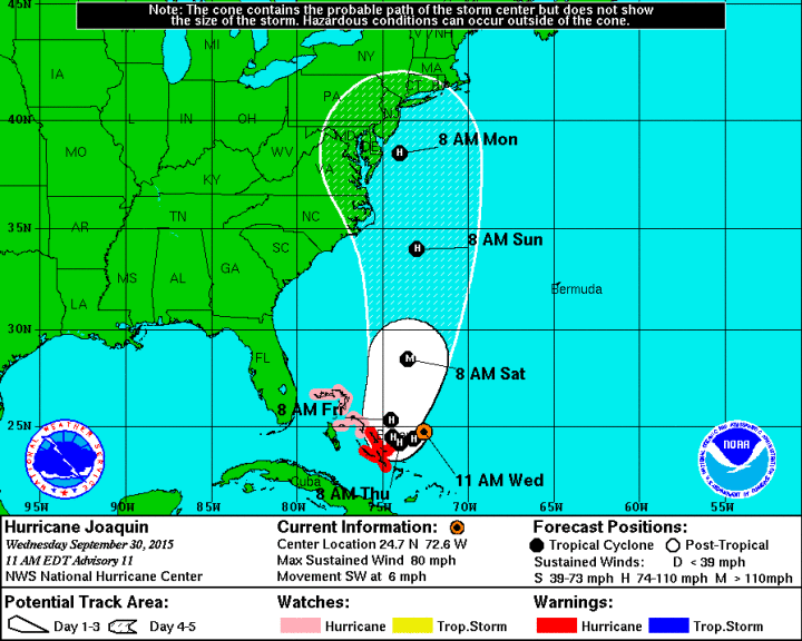

Today in why you should pay attention to the Forecast Discussion: New detail section with a threat to the US coast.
KEY MESSAGES:
1. Confidence in the details of the track forecast late in the
period remains low, since the environmental steering currents are
complex and the model guidance is inconsistent. A wide range of
outcomes is possible, from a direct impact of a major hurricane
along the U.S. east coast to a track of Joaquin out to sea away from
the coast. It is therefore way too soon to talk about specific
wind, rain, or surge impacts from Joaquin in the U.S.
2. Should the threat to the U.S. increase, any further adjustments
of the forecast to the west would likely be accompanied by an
increase in the forecast forward speed, with impacts along the coast
occurring sooner than currently forecast. A hurricane watch could
be required for portions of the U.S. coast as early as Thursday
evening.
3. Many areas of the eastern U.S. are currently experiencing heavy
rains and gusty winds associated with a frontal system. This
inclement weather is expected to continue over the next few days,
which could complicate preparations for Joaquin should it head
toward the coast.
And thanks, BTW
No problem, been really worried about this one with the trends and knew there were some users in the area. Helps that my mind goes on high alert when NJ is in play anyway with all the family I have out there.
Have been.
I've got a bad feeling about this one. The models are all over the map now & it all depends on how fast the system moves west into the short wave trough. It's coming North as Hurricane, though and that's never good. The Euro model has historically been the best predictor and that's not looking good now at all.
A "quiet" Atlantic hurricane season means little. All it takes is one to ruin your day.
http://www.tropicaltidbits.com/storminfo/11L_trac…
I've been really worried about this one too, most models seem to be converging on the left hook back into the coast scenario, though it's no guarantee. It's actually a very similar set-up to Sandy, in which the storm gets tugged back west into a trough, a rare scenario that is really surprising to see the possibility of twice in just three years.
I hope people are paying attention. Andrew was in a quiet year, and Alicia happened in a year with just 4 storms. This could be the first major hurricane to hit the US since 2005 (major hurricane doesn't mean much in reality, just look at Ike, Irene, and Sandy for proof) and people might have let their guard down, especially if this left-hooks into somewhere like Maryland.
Edit: The GFS ensembles are all over the place. Have it hitting anywhere from North Carolina to the Azores.
Those tracks clustered south of the entrance to the Chesapeake Bay look all too similar to Isabel's, which caused a 7-9 foot storm surge at high tide and a huge amount of property damage throughout. I know it's early yet but this storm was nowhere 48 hours ago. It's an indicator of just how fast things can go pear-shaped during hurricane season.
AHEM!
dp 51
rh 44
I hear it might be even wetter in AZ next week.
My desert-valley-rule -of-thumb is that 20-30% means it'll rain in the mountains.
Joaquin?!?!!?
"Build the danged fence!"
Meanwhile…
I went hiking yesterday afternoon with my dog, at our nearby lake/reservoir, which has now dipped so low that we were able to walk along the old highway, that had been underwater for the past sixty years.
Cool, but mostly scary.
Edit:I just wanted to add that 3-4 years ago some two-lane ranch roads started re-appearing in the 60 year-old reservoir for the city where I grew-up.
No full-on highway, but at least one old WPA-era bridge visible from the highway above. It would be cool to poke around, but being the drinking-water reservoir they don't let people go down there.
Once again non-stop rain in the NW.
<img src="http://www.stevenspass.com/cams/base1/" width="450">
Yikes!
Mt Lemmon here.
<img src="https://c2.staticflickr.com/8/7211/7192450440_599a05e5c3_b.jpg" width="400" height="400">
Very possible, a northwest turn would probably end up with it merging with the trough that's tugging it.
That's a cold front stuck on the east coast along with a former tropical disturbance, so parts of the east coast has had a few inches of rain this week.
GTFO!!!
Blue's 2nd RofT. : Nothing north of San Diego is going to bring rain to Tucson.
[exc. sometimes the winter jet will come direct from AK]
You know Who Else rides the winter jet from AK?
Crazy snowbillies?
Ahem…
Following those tracks, it would seem that once again Goobernor Christie is bogarting the blowjobs.
Sorry.