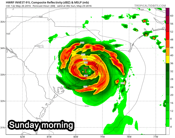
SPECIAL TROPICAL WEATHER OUTLOOK
NWS NATIONAL HURRICANE CENTER MIAMI FL
255 PM EDT THU MAY 26 2016
For the North Atlantic…Caribbean Sea and the Gulf of Mexico:
The low pressure area centered between Bermuda and the Bahamas
has an elongated circulation, although the shower activity has
been increasing during the past 24 hours. Environmental conditions
are expected to become more conducive for a tropical or subtropical
cyclone to form on Friday or Saturday while the system moves
west-northwestward or northwestward toward the southeastern United
States coast. With the Memorial Day weekend approaching, all
interests along the southeast coast from Georgia through North
Carolina should monitor the progress of this low. An Air Force
reconnaissance plane is scheduled to investigate this low on
Friday afternoon. The next Special Tropical Weather Outlook on this
disturbance will be issued by 8 PM EDT tonight. For additional
information on this system, see High Seas Forecasts issued by the
National Weather Service.
* Formation chance through 48 hours…medium…60 percent
* Formation chance through 5 days…high…70 percent
SPECIAL TROPICAL WEATHER OUTLOOK
NWS NATIONAL HURRICANE CENTER MIAMI FL
740 PM EDT THU MAY 26 2016
For the North Atlantic…Caribbean Sea and the Gulf of Mexico:
Shower activity associated with the low pressure area located
between Bermuda and the Bahamas has become somewhat better organized
since yesterday, and the circulation of the low has become a little
better defined. Environmental conditions are expected to be
generally conducive for a tropical or subtropical cyclone to form on
Friday or Saturday while this system moves west-northwestward or
northwestward toward the southeastern United States coast. All
interests along the southeast coast from Georgia through North
Carolina should monitor the progress of this low. An Air Force
Reserve Hurricane Hunter aircraft is scheduled to investigate the
low on Friday afternoon. The next Special Tropical Weather Outlook
on this disturbance will be issued by 8 AM EDT Friday morning. For
additional information on this system, see High Seas Forecasts
issued by the National Weather Service.
* Formation chance through 48 hours…high…80 percent
* Formation chance through 5 days…high…80 percent
Looks like recent lightning in N.Az. has started a few fires. More on the way up there. Dry down here, but Memorial Weekend it's traditional for some yahoos or otherwise careless persons to start a few . http://gacc.nifc.gov/swcc/predictive/intelligence…
I'll bet they do, but it's only on a white board in the lunch room.
Oh man, would make a StupidCarelessMotherFuckerIndex . Maps !! Modeling !!!!!! Use something like pressure gradient maps .Derp gradient??????OH MAN!!!!!!!!
Those are important to have. I have the same relationship with Trout Mask Replica" I pick it up and spin a few select cuts when I need a dose of ancient, anarchic blues-tinged weirdness. I like Bongo Fury for similar reasons and C.B.'s bellowing into the mic always makes me laugh.
Free water, dude! You could fill a cistern – like they do in the Caribbean – for those really dry times.
Not with vodka, though that would be really interesting.
The European model suggests the potential for heavier rain to D.C.’s south and east from Richmond through southern Maryland into the Delmarva.
"Forty Signs of
RainFFFFFFUUUUUUU…."Somebody's gonna get a cycolonic.
HIgh cyclonic.
Seeing a few models keeping it way west of there. GFS takes it into GA and up into TN/KY/OH.
Edit: Amusingly, a few take it way east too. Huge model spread right now. The forecast should be ¯_ツ_/¯
SPECIAL TROPICAL WEATHER OUTLOOK
NWS NATIONAL HURRICANE CENTER MIAMI FL
255 PM EDT THU MAY 26 2016
For the North Atlantic…Caribbean Sea and the Gulf of Mexico:
The low pressure area centered between Bermuda and the Bahamas
has an elongated circulation, although the shower activity has
been increasing during the past 24 hours. Environmental conditions
are expected to become more conducive for a tropical or subtropical
cyclone to form on Friday or Saturday while the system moves
west-northwestward or northwestward toward the southeastern United
States coast. With the Memorial Day weekend approaching, all
interests along the southeast coast from Georgia through North
Carolina should monitor the progress of this low. An Air Force
reconnaissance plane is scheduled to investigate this low on
Friday afternoon. The next Special Tropical Weather Outlook on this
disturbance will be issued by 8 PM EDT tonight. For additional
information on this system, see High Seas Forecasts issued by the
National Weather Service.
* Formation chance through 48 hours…medium…60 percent
* Formation chance through 5 days…high…70 percent
SPECIAL TROPICAL WEATHER OUTLOOK
NWS NATIONAL HURRICANE CENTER MIAMI FL
740 PM EDT THU MAY 26 2016
For the North Atlantic…Caribbean Sea and the Gulf of Mexico:
Shower activity associated with the low pressure area located
between Bermuda and the Bahamas has become somewhat better organized
since yesterday, and the circulation of the low has become a little
better defined. Environmental conditions are expected to be
generally conducive for a tropical or subtropical cyclone to form on
Friday or Saturday while this system moves west-northwestward or
northwestward toward the southeastern United States coast. All
interests along the southeast coast from Georgia through North
Carolina should monitor the progress of this low. An Air Force
Reserve Hurricane Hunter aircraft is scheduled to investigate the
low on Friday afternoon. The next Special Tropical Weather Outlook
on this disturbance will be issued by 8 AM EDT Friday morning. For
additional information on this system, see High Seas Forecasts
issued by the National Weather Service.
* Formation chance through 48 hours…high…80 percent
* Formation chance through 5 days…high…80 percent
So the elongated circulation has become better defined
Now you're made it sound all dirty.
Thanks.
<img src="https://media.giphy.com/media/C3CUJPTRqNk88/giphy.gif" />
Woah!
It's mesmerizing!
I feel wiggly now.
Looks like recent lightning in N.Az. has started a few fires. More on the way up there. Dry down here, but Memorial Weekend it's traditional for some yahoos or otherwise careless persons to start a few .
http://gacc.nifc.gov/swcc/predictive/intelligence…
"Predictive Intelligence". Does the NIFC have a "Predictive Ignorance" algorithm for the invasion of stupid drunks also ?
I'll bet they do, but it's only on a white board in the lunch room.
Oh man, would make a StupidCarelessMotherFuckerIndex . Maps !! Modeling !!!!!! Use something like pressure gradient maps .Derp gradient??????OH MAN!!!!!!!!
This sounds like a great weekend project. Useful too.
At least that scenario would likely be mid-week for us.
<img src="http://dailypostal.com/wp-content/uploads/2010/12/Captain-Beefheart-and-His-Magic-Band.jpg">
You're one of the few people I know who's heard of (and can tolerate) The Captain.
| "Give me Bas-Relief! |
Those are important to have. I have the same relationship with Trout Mask Replica" I pick it up and spin a few select cuts when I need a dose of ancient, anarchic blues-tinged weirdness. I like Bongo Fury for similar reasons and C.B.'s bellowing into the mic always makes me laugh.
I'll say. It spiked 90 in the cities out here, it's 2052 hrs and 77 F, with 66% RH. Too hot too fast.
Shame about the sunlight. It's really going to cut down on | the Vodka production. |
Free water, dude! You could fill a cistern – like they do in the Caribbean – for those really dry times.
Not with vodka, though that would be really interesting.
Couldn't hurt to set it up for a trial run, work out the kinks, specially since fresh water will be the Gold of the future.
That's an experienced design team, right there.