BULLETIN
HURRICANE MATTHEW ADVISORY NUMBER 35
NWS NATIONAL HURRICANE CENTER MIAMI FL AL142016
500 PM EDT THU OCT 06 2016
…EYE OF EXTREMELY DANGEROUS HURRICANE MATTHEW ABOUT TO HIT
FREEPORT IN THE BAHAMAS…
…POTENTIALLY DISASTROUS IMPACTS FOR FLORIDA…
SUMMARY OF 500 PM EDT…2100 UTC…INFORMATION
———————————————-
LOCATION…26.2N 78.6W
ABOUT 25 MI…40 KM SSE OF FREEPORT GRAND BAHAMA ISLAND
ABOUT 100 MI…160 KM ESE OF WEST PALM BEACH FLORIDA
MAXIMUM SUSTAINED WINDS…140 MPH…220 KM/H
PRESENT MOVEMENT…NW OR 325 DEGREES AT 13 MPH…20 KM/H
MINIMUM CENTRAL PRESSURE…938 MB…27.70 INCHES
WATCHES AND WARNINGS
——————–
CHANGES WITH THIS ADVISORY:
The Hurricane Warning has been extended northward to South Santee
River, South Carolina.
A Tropical Storm Warning has been issued from north of South Santee
River to Surf City, North Carolina.
The Government of the Bahamas has discontinued the Hurricane Warning
for the Central Bahamas.
SUMMARY OF WATCHES AND WARNINGS IN EFFECT:
A Hurricane Warning is in effect for…
* Northwestern Bahamas, including the Abacos, Andros Island, Berry
Islands, Bimini, Eleuthera, Grand Bahama Island, and New Providence
* North of Golden Beach to South Santee River
* Lake Okeechobee
A Tropical Storm Warning is in effect for…
* Chokoloskee to Golden Beach
* Florida Keys from Seven Mile Bridge eastward
* Florida Bay
* Anclote River to Suwannee River
* North of South Santee River to Surf City
A Tropical Storm Watch is in effect for…
* North of Chokoloskee to Anclote River
Product: NOAA Vortex Message (URNT12 KWBC)
Transmitted: 6th day of the month at 22:40Z
Agency: National Oceanic and Atmospheric Administration (NOAA)
Aircraft: Lockheed WP-3D Orion (Reg. Num. N43RF)
Storm Number & Year: 14 in 2016
Storm Name: Matthew (flight in the North Atlantic basin)
Mission Number: 30
Observation Number: 21
A. Time of Center Fix: 6th day of the month at 22:09:52Z
B. Center Fix Coordinates: 26°20'N 78°48'W (26.3333N 78.8W)
B. Center Fix Location: 82 statute miles (133 km) to the ESE (108°) from West Palm Beach, FL, USA.
C. Minimum Height at Standard Level: 2,571m (8,435ft) at 700mb
D & E. Estimated (by SFMR or visually) Maximum Surface Wind Inbound: Not Available
F. Maximum Flight Level Wind Inbound: From 135° at 115kts (From the SE at ~ 132.3mph)
G. Location of Maximum Flight Level Wind Inbound: 9 nautical miles (10 statute miles) to the NE (44°) of center fix
H. Minimum Sea Level Pressure: 939mb (27.73 inHg)
I. Maximum Flight Level Temp & Pressure Altitude Outside Eye: 11°C (52°F) at a pressure alt. of 3,074m (10,085ft)
J. Maximum Flight Level Temp & Pressure Altitude Inside Eye: 20°C (68°F) at a pressure alt. of 3,060m (10,039ft)
K. Dewpoint Temp (collected at same location as temp inside eye): 11°C (52°F)
K. Sea Surface Temp (collected at same location as temp inside eye): Not Available
L. Eye Character: Closed Wall
M. Eye Shape: Concentric (has an inner and outer eye)
M. Inner Eye Diameter: 8 nautical miles (9 statute miles)
M. Outer Eye Diameter: 50 nautical miles (58 statute miles)
N. Fix Determined By: Penetration, Radar, Wind, Pressure and Temperature
N. Fix Level: 700mb
O. Navigational Fix Accuracy: 0.01 nautical miles
O. Meteorological Accuracy: 1 nautical mile
Remarks Section:
Maximum Flight Level Wind: 121kts (~ 139.2mph) which was observed 10 nautical miles (12 statute miles) to the NE (41°) from the flight level center at 19:20:24Z
Maximum Flight Level Temp: 20°C (68°F) which was observed 8 nautical miles to the SW (226°) from the flight level center
Dropsonde Surface Wind at Center: From 100° at 7kts (From the E at 8mph)
I haven't been this nervous about a hurricane since Katrina, and both times I was well over 1,000 miles away.
As a programming note, there will be no separate foo'ball post tonight because:
A) Hurricane
B) It's Thursday anyway
C) There's a really big hurricane out there
5) Hurricane.
But as a public service, Kansas City, New Orleans, Seattle and (thankfully) Jacksonville all have byes this week. There are early Sunday games in Miami and Baltimore and the Monday night game is in Charlotte. No doubt the Miami game will be postponed/moved; Carolina probably as well. Possible even Baltimore.
All that being said, obviously there are things more important than football. This thing is a monster. Let's hope it does less damage than predicted.
I think Carolina and Baltimore will be safe, but I worry about Miami. Even if Miami gets off with only tropical storm winds, travel could be near impossible due to damage to the north.
HURRICANE MATTHEW TROPICAL CYCLONE UPDATE
NWS NATIONAL HURRICANE CENTER MIAMI FL AL142016
700 PM EDT THU OCT 06 2016
…98-MPH WIND GUST REPORTED AT SETTLEMENT POINT…
…7 PM EDT POSITION UPDATE…
A NOAA station at Settlement Point on Grand Bahama recently reported
a sustained wind of 75 mph (120 km/h) and a wind gust of 98 mph
(157 km/h). A National Ocean Service station at Lake Worth Pier,
Florida, recently reported a sustained wind of 44 mph (71 km/h) and
a wind gust of 55 mph (89 km/h).
SUMMARY OF 700 PM EDT…2300 UTC…INFORMATION
———————————————–
LOCATION…26.4N 78.8W
ABOUT 5 MI…10 KM S OF FREEPORT GRAND BAHAMA
ABOUT 85 MI…135 KM ESE OF WEST PALM BEACH FLORIDA
MAXIMUM SUSTAINED WINDS…140 MPH…220 KM/H
PRESENT MOVEMENT…NW OR 325 DEGREES AT 13 MPH…22 KM/H
MINIMUM CENTRAL PRESSURE…939 MB…27.73 INCHES
OK so the one hurricane I rode out on the island was a total mistake. It was running up the coast (as they do) and evacs were *strongly encouraged* We waited way too long of course and the low roads and bridge approaches flooded out.
My roomies and I looked at each other and said "Shit, we gotta get to the store for breakfast stuff before everyone empties it out !"
So we run up to the grocery store. Crowds had already been and gone, but there were plenty of eggs, lots of milk, butter, bread, all the things we needed.
However, the Entenmann's rack: totally wiped out.
When you're faced with an existential crisis, only crumb buns, chocolate covered donuts and jelly rolls will do.
BULLETIN
HURRICANE MATTHEW INTERMEDIATE ADVISORY NUMBER 35A
NWS NATIONAL HURRICANE CENTER MIAMI FL AL142016
800 PM EDT THU OCT 06 2016
…EYE OF EXTREMELY DANGEROUS HURRICANE MATTHEW OVER THE WESTERN
END OF GRAND BAHAMA ISLAND…
…TROPICAL STORM CONDITIONS SPREADING ONTO THE FLORIDA EAST
COAST…
SUMMARY OF 800 PM EDT…0000 UTC…INFORMATION
———————————————-
LOCATION…26.6N 78.9W
ABOUT 15 MI…25 KM WNW OF FREEPORT GRAND BAHAMA ISLAND
ABOUT 75 MI…120 KM E OF WEST PALM BEACH FLORIDA
MAXIMUM SUSTAINED WINDS…130 MPH…210 KM/H
PRESENT MOVEMENT…NW OR 325 DEGREES AT 13 MPH…20 KM/H
MINIMUM CENTRAL PRESSURE…939 MB…27.73 INCHES
WATCHES AND WARNINGS
——————–
CHANGES WITH THIS ADVISORY:
The Hurricane Warning has been changed to a Tropical Storm Warning
from south of Boca Raton, Florida, to north of Golden Beach.
The Tropical Warning has been discontinued south of Ocean Reef,
Florida, to Chokoloskee.
The Tropical Storm Watch has been discontinued south of
Englewood to Chokoloskee.
SUMMARY OF WATCHES AND WARNINGS IN EFFECT:
A Hurricane Warning is in effect for…
* Northwestern Bahamas, including the Abacos, Andros Island, Berry
Islands, Bimini, Eleuthera, Grand Bahama Island, and New Providence
* Boca Raton to South Santee River
* Lake Okeechobee
A Tropical Storm Warning is in effect for…
* Ocean Reef to south of Boca Raton
* Florida Keys from Seven Mile Bridge eastward
* Florida Bay
* Anclote River to Suwannee River
* North of South Santee River to Surf City
A Tropical Storm Watch is in effect for…
* Englewood to Anclote River
HURRICANE MATTHEW TROPICAL CYCLONE UPDATE
NWS NATIONAL HURRICANE CENTER MIAMI FL AL142016
900 PM EDT THU OCT 06 2016
…EYE OF MATTHEW NOW NORTHWEST OF GRAND BAHAMA…
…9 PM EDT POSITION UPDATE…
An automated station at West End on Grand Bahama recently reported a
sustained wind of 73 mph (117 km/h) and a pressure of 947.1 mb
(27.97 inches). Palm Beach International Airport recently reported
a wind gust of 50 mph (80 km/h).
SUMMARY OF 900 PM EDT…0100 UTC…INFORMATION
———————————————–
LOCATION…26.8N 79.0W
ABOUT 25 MI…40 KM NNW OF FREEPORT GRAND BAHAMA ISLAND
ABOUT 70 MI…110 KM E OF WEST PALM BEACH FLORIDA
MAXIMUM SUSTAINED WINDS…130 MPH…210 KM/H
PRESENT MOVEMENT…NW OR 325 DEGREES AT 13 MPH…20 KM/H
MINIMUM CENTRAL PRESSURE…939 MB…27.73 INCHES
"But while Clapton himself has long since crossed over into milquetoast balladry and bloodless professionalism, the album he recorded during that month clearly retains an otherworldly hold on the musician's more obsessive fans."
Hehe
Yeah, well, Kansas was big at the time too.
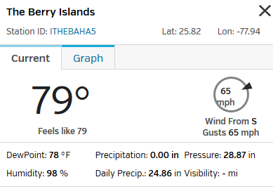
It's been about an hour since | the Berry Island Station reported in. | They might be offline for the duration, but wow, what a run. Right through the worst of a Cat 4 storm.
Could be. From the stations graph logs, they dropped out 5-6 times over the storm event – probably power outages. They were online all through the 90- 100 mph + gusts. Last wind reading was 45 mph. Maybe a tree fell on them.
BTW, it's a tiny little island Destination Resort facility for the Carnival Cruise line. Google Sat view has a Cruise ship anchored off and crewboats going back and forth.
I hope they don't have all the dinosaurs there, like Jurassic Park. That could ruin your whole vacation.
Prob. | They're up again now. | They have to have cable internet, I doubt they'd be able to maintain sat uplink through all that water and charge in the atmosphere.
Elections supervisors typically see a surge in voter interest immediately before the registration closes. About 50,000 people registered during the final five days in 2012, according to University of Florida professor Daniel A. Smith, who studies Florida voting trends.
“Right at the end, people feel the urgency to do something,” said Gihan Perera, head of Florida New Majority, which called off its sign-up events at schools, churches and football games in South Florida and the Jacksonville area.
FFS…
Cancellations began Wednesday: When President Barack Obama called into Miami’s 99 Jamz radio station, host Felisha Monet told him they’d called off a registration drive.
Engage Miami Civic Fund had intended to register students at Florida International University and Miami Dade College, as well as at several high schools, on Thursday and Friday. The group is trying to reschedule for Monday and Tuesday but acknowledged that the busy weekend events will be lost.
BULLETIN
HURRICANE MATTHEW ADVISORY NUMBER 37
NWS NATIONAL HURRICANE CENTER MIAMI FL AL142016
500 AM EDT FRI OCT 07 2016
…DANGEROUS HURRICANE MATTHEW MOVING PARALLEL TO AND JUST
OFFSHORE OF THE EAST COAST OF FLORIDA…
…WESTERN EYEWALL WITH HURRICANE-FORCE WINDS APPROACHING CAPE
CANAVERAL…
SUMMARY OF 500 AM EDT…0900 UTC…INFORMATION
———————————————-
LOCATION…28.2N 80.0W
ABOUT 40 MI…65 KM ESE OF CAPE CANAVERAL FLORIDA
ABOUT 90 MI…150 KM SE OF DAYTONA BEACH FLORIDA
MAXIMUM SUSTAINED WINDS…120 MPH…195 KM/H
PRESENT MOVEMENT…NNW OR 330 DEGREES AT 13 MPH…20 KM/H
MINIMUM CENTRAL PRESSURE…938 MB…27.70 INCHES
HAZARDS AFFECTING LAND
———————-
WIND: Hurricane conditions should diminish over portions of the
northwestern Bahamas this morning.
Hurricane conditions are expected to first reach the hurricane
warning area in Florida during the next several hours and will
spread northward within the warning area through today. Tropical
storm conditions will continue to spread northward in the warning
area along the Florida east coast today.
Hurricane conditions are expected to spread northward in the warning
area in Georgia and South Carolina tonight and Saturday with
tropical storm conditions expected later today.
Winds increase rapidly in elevation in a tropical cyclone.
Residents in high-rise buildings should be aware that the winds at
the top of a 30-story building will be, on average, about one
Saffir-Simpson category higher than the winds near the surface.
Tropical storm conditions are expected in the tropical storm warning
area in the Carolinas tonight and Saturday.
STORM SURGE: The combination of a dangerous storm surge, the tide,
and large and destructive waves will cause normally dry areas near
the coast to be flooded by rising waters moving inland from the
shoreline. The water could reach the following heights above ground
if the peak surge occurs at the time of high tide…
Sebastian Inlet, Florida, to Edisto Beach, South Carolina, including
portions of the St. Johns River…7 to 11 ft
Edisto Beach to South Santee River, South Carolina…4 to 6 ft
Jupiter Inlet to Sebastian Inlet, Florida…4 to 6 ft
South Santee River, South Carolina, to Cape Fear, North Carolina…2
to 4 ft
The deepest water will occur along the immediate coast in areas of
onshore winds. Surge-related flooding depends on the relative
timing of the surge and the tidal cycle, and can vary greatly over
short distances. Large waves generated by Matthew will cause water
rises to occur well in advance of and well away from the track of
the center. For information specific to your area, please see
products issued by your local National Weather Service forecast
office.
Water levels in the northwestern Bahamas should continue to subside
during the day.
There is a danger of life-threatening inundation during the next 36
hours along the Florida east coast, the Georgia coast, and the South
Carolina coast from Jupiter Inlet, Florida, to South Santee River,
South Carolina. There is the possibility of life-threatening
inundation during the next 48 hours from north of South Santee
River, South Carolina, to Cape Fear, North Carolina. For a depiction
of areas at risk, please see the Prototype National Weather Service
Storm Surge Watch/Warning Graphic. For information specific to your
area, please see products issued by your local National Weather
Service forecast office.
The Prototype Storm Surge Watch/Warning Graphic is a depiction of
areas that would qualify for inclusion under a storm surge watch or
warning currently under development by the National Weather Service
and planned for operational use in 2017. The Prototype Graphic is
available at hurricanes.gov.
RAINFALL: Matthew is expected to produce additional rain
accumulations of 1 to 2 inches over the northwestern Bahamas…with
isolated maximum storm-total amounts of 15 inches. Matthew is
expected to produce total rain accumulations of 8 to 12 inches over
the Atlantic coast of the United States from central Florida to
eastern North Carolina…with possible isolated maximum amounts of
15 inches. This rainfall may result in flooding and flash flooding.
TORNADOES: An isolated tornado or two is possible along the
east-central Florida coast today.
SURF: Swells generated by Matthew will continue to affect portions
of the north coast of Cuba and the Bahamas during the next few days,
and will spread northward along the east coast of Florida and the
southeast U.S. coast through the weekend. These swells will likely
cause life-threatening surf and rip current conditions. Please
consult products from your local weather office.
NEXT ADVISORY
————-
Next intermediate advisory at 800 AM EDT.
Next complete advisory at 1100 AM EDT.
The number of people killed in Haiti by the devastating effects of Hurricane Matthew rose to at least 478 on Friday as rescue workers and aid agencies battled to reach remote areas of the country, assess the damage and deliver relief.
From Guardian again (9:35 EDT, if my math is right):
Florida Governor Rick Scott just updated the nation on Hurricane Matthew’s impacts so far. Here are the highlights:
600,000 people in the state are without power
22,000 people are in shelters
145 shelters are open in the state
All interstates in Florida remain open, without tolls
Damage assessments are just beginning
The federal government is providing significant help to the state, including food, water, tarps, generators, search and rescue teams, hazmat assessment teams, cots and blankets.
“We’re only halfway through, we’re going to have more outages,” said Scott. “Power saves lives. We want everybody to get their power back as soon as possible.”
From the Guardian: St. Augustine’s mayor, Nancy Shaver, was just on CNN, where she said officials “believe about 50% of the people who should have evacuated did not.”
“It’s been quite a serious problem with this storm,” she said.
“We have obviously lost power, we turned off the water as a precautionary measure at 8pm last night,” she said. “It’s important for people to take it seriously, people who do not put our first responders at risk.”
Guardian sez. …… authorities reported five storm-related deaths in Florida, four in St Lucie County.
Not Haiti, but may quiet the assholes a little bit.
BULLETIN
HURRICANE MATTHEW INTERMEDIATE ADVISORY NUMBER 41A
NWS NATIONAL HURRICANE CENTER MIAMI FL AL142016
800 AM EDT SAT OCT 08 2016
…STRONG WINDS AND DANGEROUS STORM SURGE AFFECTING THE COAST OF
SOUTH CAROLINA…
…HEAVY RAINS AND GUSTY WINDS SPREADING INLAND…
SUMMARY OF 800 AM EDT…1200 UTC…INFORMATION
———————————————-
LOCATION…32.5N 79.8W
ABOUT 20 MI…35 KM SSE OF CHARLESTON SOUTH CAROLINA
MAXIMUM SUSTAINED WINDS…85 MPH…140 KM/H
PRESENT MOVEMENT…NE OR 45 DEGREES AT 12 MPH…19 KM/H
MINIMUM CENTRAL PRESSURE…962 MB…28.41 INCHES
UPDATE: Tybee Island apparently experienced a storm surge of 12 feet (!) and Savannah
is experiencing major flooding and |according to WTOC, |Hurricane Matthew’s storm surge of 12.56 feet broke the record set by Hurricane David in 1979as the highest tide in Savannah’s history.
It's still working despite being in the outer eyewall on the back side, what a legend.
Did they put it inside a cement block?
Hunker down, bunker down, you name it.
Daily precip- 24.86 inches, what's 0.6 meters between friends? How much of that was coming horizontally?
All of it, Katie
Freeport, Bahamas is going to be demolished in the next few hours at this rate. Worst of the storm looks to track right over the town.
Matthew: accelerated personal weather station weathering.
| Required reading |
Meanwhile, in Kathmandu<img src="http://media.salon.com/2016/10/goats_lge.jpg" />
BULLETIN
HURRICANE MATTHEW ADVISORY NUMBER 35
NWS NATIONAL HURRICANE CENTER MIAMI FL AL142016
500 PM EDT THU OCT 06 2016
…EYE OF EXTREMELY DANGEROUS HURRICANE MATTHEW ABOUT TO HIT
FREEPORT IN THE BAHAMAS…
…POTENTIALLY DISASTROUS IMPACTS FOR FLORIDA…
SUMMARY OF 500 PM EDT…2100 UTC…INFORMATION
———————————————-
LOCATION…26.2N 78.6W
ABOUT 25 MI…40 KM SSE OF FREEPORT GRAND BAHAMA ISLAND
ABOUT 100 MI…160 KM ESE OF WEST PALM BEACH FLORIDA
MAXIMUM SUSTAINED WINDS…140 MPH…220 KM/H
PRESENT MOVEMENT…NW OR 325 DEGREES AT 13 MPH…20 KM/H
MINIMUM CENTRAL PRESSURE…938 MB…27.70 INCHES
WATCHES AND WARNINGS
——————–
CHANGES WITH THIS ADVISORY:
The Hurricane Warning has been extended northward to South Santee
River, South Carolina.
A Tropical Storm Warning has been issued from north of South Santee
River to Surf City, North Carolina.
The Government of the Bahamas has discontinued the Hurricane Warning
for the Central Bahamas.
SUMMARY OF WATCHES AND WARNINGS IN EFFECT:
A Hurricane Warning is in effect for…
* Northwestern Bahamas, including the Abacos, Andros Island, Berry
Islands, Bimini, Eleuthera, Grand Bahama Island, and New Providence
* North of Golden Beach to South Santee River
* Lake Okeechobee
A Tropical Storm Warning is in effect for…
* Chokoloskee to Golden Beach
* Florida Keys from Seven Mile Bridge eastward
* Florida Bay
* Anclote River to Suwannee River
* North of South Santee River to Surf City
A Tropical Storm Watch is in effect for…
* North of Chokoloskee to Anclote River
Aaaand Matt Drudge is an asshole.
@DRUDGE
The deplorables are starting to wonder if govt has been lying to them about Hurricane Matthew intensity to make exaggerated point on climate
@capitalweather
Don't believe the morons who are telling you this is no big deal. Hurricane #Matthew is deadly serious.
we look forward to chickenshit Drudge's report on Florida beach that it's a dud (with votes)
http://www.nhc.noaa.gov/text/WTUS82-KMLB.shtml Holy shit, this is strong wording from NWS Melbourne.
Man I'm glad my friend got out of Dodge.
Hope Savannah and Charleston don't get damaged too much. Love those places, particularly Savannah.
Have another friend whose parents live in Port St. Lucie, she files this report (630 eastern time)
"They took the dog out for a bit and said the winds were 15-25 now. They said it should be bad at 8pm eastern".
Her dad is former coast guard and prepped to the teeth, but if I were him, I'd have gotten out of Dodge. They're only about 10 miles inland.
Could be some damage, but if they're 10 miles inland and that far south they should be okay? Might be more like a cat 1 there.
I don't think so. They're near the intercoastal waterway, north of Jupiter, south of Melbourne. I hope it isn't bad for them there.
Wait, they're near the waterway? Okay, that changes a lot. Uh… Yeah, I'd get the hell out in that case, I thought they were farther inland than that.
Product: NOAA Vortex Message (URNT12 KWBC)
Transmitted: 6th day of the month at 22:40Z
Agency: National Oceanic and Atmospheric Administration (NOAA)
Aircraft: Lockheed WP-3D Orion (Reg. Num. N43RF)
Storm Number & Year: 14 in 2016
Storm Name: Matthew (flight in the North Atlantic basin)
Mission Number: 30
Observation Number: 21
A. Time of Center Fix: 6th day of the month at 22:09:52Z
B. Center Fix Coordinates: 26°20'N 78°48'W (26.3333N 78.8W)
B. Center Fix Location: 82 statute miles (133 km) to the ESE (108°) from West Palm Beach, FL, USA.
C. Minimum Height at Standard Level: 2,571m (8,435ft) at 700mb
D & E. Estimated (by SFMR or visually) Maximum Surface Wind Inbound: Not Available
F. Maximum Flight Level Wind Inbound: From 135° at 115kts (From the SE at ~ 132.3mph)
G. Location of Maximum Flight Level Wind Inbound: 9 nautical miles (10 statute miles) to the NE (44°) of center fix
H. Minimum Sea Level Pressure: 939mb (27.73 inHg)
I. Maximum Flight Level Temp & Pressure Altitude Outside Eye: 11°C (52°F) at a pressure alt. of 3,074m (10,085ft)
J. Maximum Flight Level Temp & Pressure Altitude Inside Eye: 20°C (68°F) at a pressure alt. of 3,060m (10,039ft)
K. Dewpoint Temp (collected at same location as temp inside eye): 11°C (52°F)
K. Sea Surface Temp (collected at same location as temp inside eye): Not Available
L. Eye Character: Closed Wall
M. Eye Shape: Concentric (has an inner and outer eye)
M. Inner Eye Diameter: 8 nautical miles (9 statute miles)
M. Outer Eye Diameter: 50 nautical miles (58 statute miles)
N. Fix Determined By: Penetration, Radar, Wind, Pressure and Temperature
N. Fix Level: 700mb
O. Navigational Fix Accuracy: 0.01 nautical miles
O. Meteorological Accuracy: 1 nautical mile
Remarks Section:
Maximum Flight Level Wind: 121kts (~ 139.2mph) which was observed 10 nautical miles (12 statute miles) to the NE (41°) from the flight level center at 19:20:24Z
Maximum Flight Level Temp: 20°C (68°F) which was observed 8 nautical miles to the SW (226°) from the flight level center
Dropsonde Surface Wind at Center: From 100° at 7kts (From the E at 8mph)
I haven't been this nervous about a hurricane since Katrina, and both times I was well over 1,000 miles away.
As a programming note, there will be no separate foo'ball post tonight because:
A) Hurricane
B) It's Thursday anyway
C) There's a really big hurricane out there
5) Hurricane.
But as a public service, Kansas City, New Orleans, Seattle and (thankfully) Jacksonville all have byes this week. There are early Sunday games in Miami and Baltimore and the Monday night game is in Charlotte. No doubt the Miami game will be postponed/moved; Carolina probably as well. Possible even Baltimore.
All that being said, obviously there are things more important than football. This thing is a monster. Let's hope it does less damage than predicted.
I think Carolina and Baltimore will be safe, but I worry about Miami. Even if Miami gets off with only tropical storm winds, travel could be near impossible due to damage to the north.
HURRICANE MATTHEW TROPICAL CYCLONE UPDATE
NWS NATIONAL HURRICANE CENTER MIAMI FL AL142016
700 PM EDT THU OCT 06 2016
…98-MPH WIND GUST REPORTED AT SETTLEMENT POINT…
…7 PM EDT POSITION UPDATE…
A NOAA station at Settlement Point on Grand Bahama recently reported
a sustained wind of 75 mph (120 km/h) and a wind gust of 98 mph
(157 km/h). A National Ocean Service station at Lake Worth Pier,
Florida, recently reported a sustained wind of 44 mph (71 km/h) and
a wind gust of 55 mph (89 km/h).
SUMMARY OF 700 PM EDT…2300 UTC…INFORMATION
———————————————–
LOCATION…26.4N 78.8W
ABOUT 5 MI…10 KM S OF FREEPORT GRAND BAHAMA
ABOUT 85 MI…135 KM ESE OF WEST PALM BEACH FLORIDA
MAXIMUM SUSTAINED WINDS…140 MPH…220 KM/H
PRESENT MOVEMENT…NW OR 325 DEGREES AT 13 MPH…22 KM/H
MINIMUM CENTRAL PRESSURE…939 MB…27.73 INCHES
https://twitter.com/RantingOwl/status/78373234758… holy shit Florida lmao
That's beautiful.
OK so the one hurricane I rode out on the island was a total mistake. It was running up the coast (as they do) and evacs were *strongly encouraged* We waited way too long of course and the low roads and bridge approaches flooded out.
My roomies and I looked at each other and said "Shit, we gotta get to the store for breakfast stuff before everyone empties it out !"
So we run up to the grocery store. Crowds had already been and gone, but there were plenty of eggs, lots of milk, butter, bread, all the things we needed.
However, the Entenmann's rack: totally wiped out.
When you're faced with an existential crisis, only crumb buns, chocolate covered donuts and jelly rolls will do.
rofl So weird buying patterns are normal? Amazing.
Stress Eating.
"We're all gonna die! I'm goin' out for donuts!"
Makes perfect sense.
Plus, donuts never die!
Um, and then there's this from Shep Smith: http://jezebel.com/shep-smith-to-all-those-in-mic…
I made the mistake of reading the comments and now I need eye bleach.
The voice of reason at fox!
[The Rude Pundit wades in.]
Go ahead, Matt – take a stroll on the beach tomorrow morning. No, really, it's cool.
000
WTNT34 KNHC 062354
TCPAT4
BULLETIN
HURRICANE MATTHEW INTERMEDIATE ADVISORY NUMBER 35A
NWS NATIONAL HURRICANE CENTER MIAMI FL AL142016
800 PM EDT THU OCT 06 2016
…EYE OF EXTREMELY DANGEROUS HURRICANE MATTHEW OVER THE WESTERN
END OF GRAND BAHAMA ISLAND…
…TROPICAL STORM CONDITIONS SPREADING ONTO THE FLORIDA EAST
COAST…
SUMMARY OF 800 PM EDT…0000 UTC…INFORMATION
———————————————-
LOCATION…26.6N 78.9W
ABOUT 15 MI…25 KM WNW OF FREEPORT GRAND BAHAMA ISLAND
ABOUT 75 MI…120 KM E OF WEST PALM BEACH FLORIDA
MAXIMUM SUSTAINED WINDS…130 MPH…210 KM/H
PRESENT MOVEMENT…NW OR 325 DEGREES AT 13 MPH…20 KM/H
MINIMUM CENTRAL PRESSURE…939 MB…27.73 INCHES
WATCHES AND WARNINGS
——————–
CHANGES WITH THIS ADVISORY:
The Hurricane Warning has been changed to a Tropical Storm Warning
from south of Boca Raton, Florida, to north of Golden Beach.
The Tropical Warning has been discontinued south of Ocean Reef,
Florida, to Chokoloskee.
The Tropical Storm Watch has been discontinued south of
Englewood to Chokoloskee.
SUMMARY OF WATCHES AND WARNINGS IN EFFECT:
A Hurricane Warning is in effect for…
* Northwestern Bahamas, including the Abacos, Andros Island, Berry
Islands, Bimini, Eleuthera, Grand Bahama Island, and New Providence
* Boca Raton to South Santee River
* Lake Okeechobee
A Tropical Storm Warning is in effect for…
* Ocean Reef to south of Boca Raton
* Florida Keys from Seven Mile Bridge eastward
* Florida Bay
* Anclote River to Suwannee River
* North of South Santee River to Surf City
A Tropical Storm Watch is in effect for…
* Englewood to Anclote River
https://twitter.com/NWSPodunk/status/784104835964…
Might not even be a parody anymore.
<img src="https://pbs.twimg.com/media/CuGVofJUkAANNhh.jpg">
from <a href="https://twitter.com/WrightDobbs” target=”_blank”>https://twitter.com/WrightDobbs
Wow, you know it's a catastrophe when the NWS people beat feet. Those folks even stuck it out through Andrew.
NWS doesn't listen to Jezebel comments, as it turns out!
"Trust your Instruments" are words to live by.
HURRICANE MATTHEW TROPICAL CYCLONE UPDATE
NWS NATIONAL HURRICANE CENTER MIAMI FL AL142016
900 PM EDT THU OCT 06 2016
…EYE OF MATTHEW NOW NORTHWEST OF GRAND BAHAMA…
…9 PM EDT POSITION UPDATE…
An automated station at West End on Grand Bahama recently reported a
sustained wind of 73 mph (117 km/h) and a pressure of 947.1 mb
(27.97 inches). Palm Beach International Airport recently reported
a wind gust of 50 mph (80 km/h).
SUMMARY OF 900 PM EDT…0100 UTC…INFORMATION
———————————————–
LOCATION…26.8N 79.0W
ABOUT 25 MI…40 KM NNW OF FREEPORT GRAND BAHAMA ISLAND
ABOUT 70 MI…110 KM E OF WEST PALM BEACH FLORIDA
MAXIMUM SUSTAINED WINDS…130 MPH…210 KM/H
PRESENT MOVEMENT…NW OR 325 DEGREES AT 13 MPH…20 KM/H
MINIMUM CENTRAL PRESSURE…939 MB…27.73 INCHES
Let's all keep an eye on this place in thenext few days:
1491 North Ocean Boulevard
Palm Beach, FL 33480
Lat/Long: 26.766317, -80.038008
Think it's insured?
I loathe that album.
How drunk do you think he was when they cut that one?
That came out when I was in college, and I was never that drunk.
Oh , right, sez that was after getting clean from the H. Long road back.
Henghgh? I'm familiar with 461 Ocean Boulevard…
heh. http://forums.stevehoffman.tv/threads/after-30-ye…
"But while Clapton himself has long since crossed over into milquetoast balladry and bloodless professionalism, the album he recorded during that month clearly retains an otherworldly hold on the musician's more obsessive fans."
Hehe
Yeah, well, Kansas was big at the time too.
It's been about an hour since | the Berry Island Station reported in. | They might be offline for the duration, but wow, what a run. Right through the worst of a Cat 4 storm.
rip in pieces
Could be. From the stations graph logs, they dropped out 5-6 times over the storm event – probably power outages. They were online all through the 90- 100 mph + gusts. Last wind reading was 45 mph. Maybe a tree fell on them.
BTW, it's a tiny little island Destination Resort facility for the Carnival Cruise line. Google Sat view has a Cruise ship anchored off and crewboats going back and forth.
I hope they don't have all the dinosaurs there, like Jurassic Park. That could ruin your whole vacation.
maybe they were up but the intertubes were down
Prob. | They're up again now. | They have to have cable internet, I doubt they'd be able to maintain sat uplink through all that water and charge in the atmosphere.
It's back, apparently.
YAY!!!!!!!!!!!
| Bat Boy refuses to extend voter registration deadline due to storm |
Well, we can't let a catastrophe get in the way of Party politics, amirite?
FFS…
Shame on Scott!
He's physiologically incapable of feeling shame. We'll have to do it for him.
OT LOL https://twitter.com/Rschooley?ref_src=twsrc%5Etfw
That's great Twitter.
| Nearly 100,000 households are already without power in Florida. |
Live blog should help keep up, getting super tired. Will have tomorrow to cover it though. Nice find!
Here's your Extreme Wind Warning: | Port and Cape Canaveral, | 115 mph as the eyewall approached.
000
WTNT34 KNHC 070853
TCPAT4
BULLETIN
HURRICANE MATTHEW ADVISORY NUMBER 37
NWS NATIONAL HURRICANE CENTER MIAMI FL AL142016
500 AM EDT FRI OCT 07 2016
…DANGEROUS HURRICANE MATTHEW MOVING PARALLEL TO AND JUST
OFFSHORE OF THE EAST COAST OF FLORIDA…
…WESTERN EYEWALL WITH HURRICANE-FORCE WINDS APPROACHING CAPE
CANAVERAL…
SUMMARY OF 500 AM EDT…0900 UTC…INFORMATION
———————————————-
LOCATION…28.2N 80.0W
ABOUT 40 MI…65 KM ESE OF CAPE CANAVERAL FLORIDA
ABOUT 90 MI…150 KM SE OF DAYTONA BEACH FLORIDA
MAXIMUM SUSTAINED WINDS…120 MPH…195 KM/H
PRESENT MOVEMENT…NNW OR 330 DEGREES AT 13 MPH…20 KM/H
MINIMUM CENTRAL PRESSURE…938 MB…27.70 INCHES
HAZARDS AFFECTING LAND
———————-
WIND: Hurricane conditions should diminish over portions of the
northwestern Bahamas this morning.
Hurricane conditions are expected to first reach the hurricane
warning area in Florida during the next several hours and will
spread northward within the warning area through today. Tropical
storm conditions will continue to spread northward in the warning
area along the Florida east coast today.
Hurricane conditions are expected to spread northward in the warning
area in Georgia and South Carolina tonight and Saturday with
tropical storm conditions expected later today.
Winds increase rapidly in elevation in a tropical cyclone.
Residents in high-rise buildings should be aware that the winds at
the top of a 30-story building will be, on average, about one
Saffir-Simpson category higher than the winds near the surface.
Tropical storm conditions are expected in the tropical storm warning
area in the Carolinas tonight and Saturday.
STORM SURGE: The combination of a dangerous storm surge, the tide,
and large and destructive waves will cause normally dry areas near
the coast to be flooded by rising waters moving inland from the
shoreline. The water could reach the following heights above ground
if the peak surge occurs at the time of high tide…
Sebastian Inlet, Florida, to Edisto Beach, South Carolina, including
portions of the St. Johns River…7 to 11 ft
Edisto Beach to South Santee River, South Carolina…4 to 6 ft
Jupiter Inlet to Sebastian Inlet, Florida…4 to 6 ft
South Santee River, South Carolina, to Cape Fear, North Carolina…2
to 4 ft
The deepest water will occur along the immediate coast in areas of
onshore winds. Surge-related flooding depends on the relative
timing of the surge and the tidal cycle, and can vary greatly over
short distances. Large waves generated by Matthew will cause water
rises to occur well in advance of and well away from the track of
the center. For information specific to your area, please see
products issued by your local National Weather Service forecast
office.
Water levels in the northwestern Bahamas should continue to subside
during the day.
There is a danger of life-threatening inundation during the next 36
hours along the Florida east coast, the Georgia coast, and the South
Carolina coast from Jupiter Inlet, Florida, to South Santee River,
South Carolina. There is the possibility of life-threatening
inundation during the next 48 hours from north of South Santee
River, South Carolina, to Cape Fear, North Carolina. For a depiction
of areas at risk, please see the Prototype National Weather Service
Storm Surge Watch/Warning Graphic. For information specific to your
area, please see products issued by your local National Weather
Service forecast office.
The Prototype Storm Surge Watch/Warning Graphic is a depiction of
areas that would qualify for inclusion under a storm surge watch or
warning currently under development by the National Weather Service
and planned for operational use in 2017. The Prototype Graphic is
available at hurricanes.gov.
RAINFALL: Matthew is expected to produce additional rain
accumulations of 1 to 2 inches over the northwestern Bahamas…with
isolated maximum storm-total amounts of 15 inches. Matthew is
expected to produce total rain accumulations of 8 to 12 inches over
the Atlantic coast of the United States from central Florida to
eastern North Carolina…with possible isolated maximum amounts of
15 inches. This rainfall may result in flooding and flash flooding.
TORNADOES: An isolated tornado or two is possible along the
east-central Florida coast today.
SURF: Swells generated by Matthew will continue to affect portions
of the north coast of Cuba and the Bahamas during the next few days,
and will spread northward along the east coast of Florida and the
southeast U.S. coast through the weekend. These swells will likely
cause life-threatening surf and rip current conditions. Please
consult products from your local weather office.
NEXT ADVISORY
————-
Next intermediate advisory at 800 AM EDT.
Next complete advisory at 1100 AM EDT.
$$
Forecaster Stewart
shitfuck.
The number of people killed in Haiti by the devastating effects of Hurricane Matthew rose to at least 478 on Friday as rescue workers and aid agencies battled to reach remote areas of the country, assess the damage and deliver relief.
From The Guardian's live updates: https://www.theguardian.com/world/live/2016/oct/0…
Terrible. It's only going to go up from there and I'm desperately hoping against hope that Haiti can avoid a widespread Cholera epidemic.
From Guardian again (9:35 EDT, if my math is right):
Florida Governor Rick Scott just updated the nation on Hurricane Matthew’s impacts so far. Here are the highlights:
600,000 people in the state are without power
22,000 people are in shelters
145 shelters are open in the state
All interstates in Florida remain open, without tolls
Damage assessments are just beginning
The federal government is providing significant help to the state, including food, water, tarps, generators, search and rescue teams, hazmat assessment teams, cots and blankets.
“We’re only halfway through, we’re going to have more outages,” said Scott. “Power saves lives. We want everybody to get their power back as soon as possible.”
No tolls?!
"Why not vacation now in Florida? The Toll-Free State!"
Holyshit | Storm Surge at Daytona Beach |
| Moar Storm Surge |
Awshit.
From the Guardian:
St. Augustine’s mayor, Nancy Shaver, was just on CNN, where she said officials “believe about 50% of the people who should have evacuated did not.”
“It’s been quite a serious problem with this storm,” she said.
“We have obviously lost power, we turned off the water as a precautionary measure at 8pm last night,” she said. “It’s important for people to take it seriously, people who do not put our first responders at risk.”
For Fuck's Sake, people!
Water, water, everywhere…
A little ol' hurricane is no reason to postpone your | meticulously planned "whimsical wedding" and "classic beach-chic reception," complete with floating sky lantern! |
We are Gurnavages and we can get through anything!
GODDAMN RIGHT!!!!!!!!!
Guardian sez.
…… authorities reported five storm-related deaths in Florida, four in St Lucie County.
Not Haiti, but may quiet the assholes a little bit.
000
WTNT34 KNHC 081157
TCPAT4
BULLETIN
HURRICANE MATTHEW INTERMEDIATE ADVISORY NUMBER 41A
NWS NATIONAL HURRICANE CENTER MIAMI FL AL142016
800 AM EDT SAT OCT 08 2016
…STRONG WINDS AND DANGEROUS STORM SURGE AFFECTING THE COAST OF
SOUTH CAROLINA…
…HEAVY RAINS AND GUSTY WINDS SPREADING INLAND…
SUMMARY OF 800 AM EDT…1200 UTC…INFORMATION
———————————————-
LOCATION…32.5N 79.8W
ABOUT 20 MI…35 KM SSE OF CHARLESTON SOUTH CAROLINA
MAXIMUM SUSTAINED WINDS…85 MPH…140 KM/H
PRESENT MOVEMENT…NE OR 45 DEGREES AT 12 MPH…19 KM/H
MINIMUM CENTRAL PRESSURE…962 MB…28.41 INCHES
| People have decided to ride out the hurricane on Tybee Island, | which had a recorded wind speed of | 96 mph | this morning, and the storm surge hit | right at high tide. | The worst possible scenario.
Emergency personnel won't even go out to the barrier islands to see how bad the damage is until things calm down, way later. I can tell you from Sandy experience that it will be terrible.
UPDATE: Tybee Island apparently experienced a storm surge of 12 feet (!) and Savannah
is experiencing major flooding and |according to WTOC, |Hurricane Matthew’s storm surge of 12.56 feet broke the record set by Hurricane David in 1979as the highest tide in Savannah’s history.
Awshit.
How long can you tread water?
|Wonder what the course looks like now.|
Big hitter, the Lama.
Water Hazard?