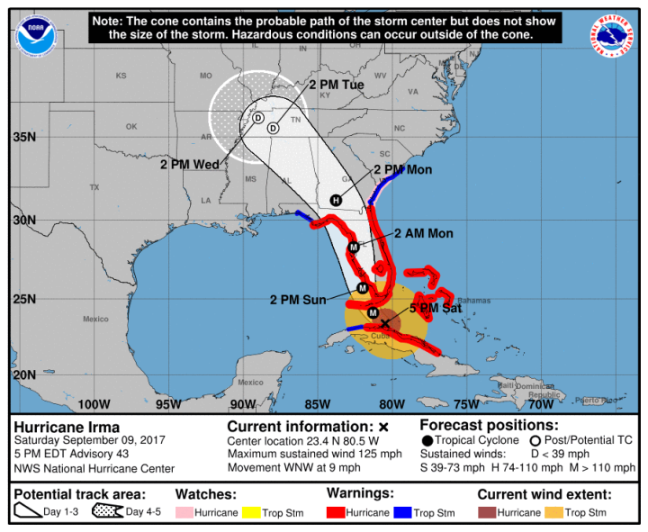
Hey sps, so the storm surge is mostly on the west coast. Ft. Myers and south through the Everglades. So it's gonna come from the NE side of Irma ? Or from the south as Irma approaches? Either seems weird to me, thinking it's the NW corner that generates the surge. http://www.nhc.noaa.gov/refresh/graphics_at1+shtm…
People keep asking about impacts so I'll just copy/paste that part of the last advisory.
HAZARDS AFFECTING LAND
———————-
STORM SURGE: The combination of a dangerous storm surge and the
tide will cause normally dry areas near the coast to be flooded by
rising waters moving inland from the shoreline. The water is
expected to reach the following HEIGHTS ABOVE GROUND if the peak
surge occurs at the time of high tide…
Cape Sable to Captiva…10 to 15 ft
Captiva to Ana Maria Island…6 to 10 ft
Card Sound Bridge through Cape Sable, including the Florida Keys…
5 to 10 ft
Ana Maria Island to Clearwater Beach, including Tampa Bay…
5 to 8 ft
North Miami Beach to Card Sound Bridge, including Biscayne Bay…
4 to 6 ft
South Santee River to Fernandina Beach…4 to 6 ft
Clearwater Beach to Ochlockonee River…4 to 6 ft
Fernandina Beach to North Miami Beach…2 to 4 ft
The deepest water will occur along the immediate coast in areas of
onshore winds, where the surge will be accompanied by large and
destructive waves. Surge-related flooding depends on the relative
timing of the surge and the tidal cycle, and can vary greatly over
short distances. For information specific to your area, please see
products issued by your local National Weather Service forecast
office.
The combination of a life-threatening storm surge and large breaking
waves will raise water levels ABOVE NORMAL TIDE LEVELS by the
following amounts within the hurricane warning area near and to the
north of the center of Irma. Near the coast, the surge will be
accompanied by large and destructive waves.
Northwestern Bahamas…3 to 6 ft
Northern coast of Cuba in the warning area…5 to 10 ft
WIND: Hurricane conditions are expected to continue within the
hurricane warning area along the north coast of Cuba through
tonight. Hurricane conditions are expected in portions of the
northwestern Bahamas tonight, and in portions of the Florida
peninsula and the Florida Keys beginning Sunday morning. Tropical
storm and hurricane conditions are expected to spread northward
across the remainder of the warning areas through Monday.
RAINFALL: Irma is expected to produce the following rain
accumulations through Wednesday:
Northern Cuba…10 to 15 inches, isolated 20 inches.
Southern Cuba…5 to 10 inches, isolated 15 inches.
Western Bahamas…3 to 6 inches, isolated 10 inches.
The Florida Keys…10 to 20 inches, isolated 25 inches.
The Florida peninsula and southeast Georgia…8 to 15 inches,
isolated 20 inches.
The eastern Florida Panhandle and southern South Carolina…4 to 8
inches, isolated 10 inches.
Rest of eastern Georgia, western South Carolina, and western North
Carolina…4 to 8 inches.
Western Georgia, eastern and northern Alabama, and southern
Tennessee…2 to 5 inches.
In all areas this rainfall may cause life-threatening flash floods
and, in some areas, mudslides.
TORNADOES: A few tornadoes are possible this evening and tonight
over south Florida, expanding northward into central Florida on
Sunday.
SURF: Swells generated by Irma are affecting the southeastern
Bahamas, the Turks and Caicos Islands and the southeast coast of the
United States today. These swells are likely to cause life-
threatening surf and rip current conditions. Please consult
products from your local weather office.
The bad news is, the shelters in Collier County, where Naples is located, aren't designed to withstand Cat 4 winds. And Tampa hasn't had a big hurricane since 1926 and hasn't done much prep.
I've lived in communities of fewer than 50 souls when the power went out, many times. You can't help but take it personally, even though you're not alone. I still have my portable generator, big enough to power a fridge and some lights, just in case.
In completely unrelated news, Eric Bolling's 19-year-old son died today. Wordsmith, opener of Al Capone's vault and not chair fanatic Gerry "Guy" Rivera conveyed these thoughtful words: https://twitter.com/GeraldoRivera/status/90657993…
Is "Guy-wrenching" what the kids are calling it these days?
How gut wrenching for those who's LGBT child committed suicide. [ crickets ]
I too am a bad person.
Down in the tweets: God bless the entire Bowling family
Of course, as Twitter user Mrs Wise points out, the real tragedy is not the senseless and tragic loss of a teenager's life, but rather that some braying moron will not appear on a particular television station. F FOX News! I will never watch again! EVER!
This is Marco Island where the storm just hit land again. Couldn't be better designed to get slammed. <img src="http://i64.tinypic.com/6o1uty.png">Those are all houses with docks.
From the redoubtable Katy Tur's Twitter: "This is all the same city. Upper right is downtown Naples. Its in the eye. The rest is going thru the wall."<img src="https://pbs.twimg.com/media/DJY-kQaXUAAwaYA.jpg"/>
I've been away from the TV most of the day, and TWC on the radio isn't very graphic.
My friends from Sanibel evacuated–to Tampa. Oy. My friend in Fort Myers is at home, in a ground floor condo. I at least advised him to get his guitars up off the floor.
My ex in Naples (and her husband, coupla friends who live nearer the Gulf) made it through the night, no power but the cell phone system is still working. Eye of the storm passed right over them, but with the storm shutters closed you couldn't tell what was happening. Going out today to start the generator. Her house is more or less in the center of this soggy map image. <img src="http://i68.tinypic.com/2mdf9g0.png">
One of the culinary delights of St George Island, up on the panhandle where I hope it won't get whacked, is something called "grouper fingers." And man are there some beautiful beaches on that barrier island the Chattahoochee River threw up when it debouched into the Gulf.
I'm amazed at the pressure-wind relationship. The core disruption from land and the large size has let it hit 933 mb with only 120 mph winds. And the 120 might be generous!
In theory that station is for peaceful scientific uses only. In practice the Navy runs it. Used to work with a guy who was the commander of it for a year. Seems there are navigational or satellite or missile or submarine communication advantages to having a facility exactly at on the axis of the planet's rotation.
I on;y did this storm because I have so many friends in harm's way. I'll probably look at some hurricane porn/aftermath footage tomorrow, then back to my regular dreck.
The Weather Channel is calling it a "strong cat 3" right now, still 110 mi southeast of Key West. I can't imagine waiting it out.
That's about exactly what it is right now, yep. I can't imagine what that area will look like in a couple of days.
Already seeing tropical storm-force winds in the keys. Sustained to 47 with gusts to 50 at Big Pine Key.
Same station just reported a wind gust to 60 mph. The first gust in Florida above severe limits.
<img src="https://scontent-sjc2-1.xx.fbcdn.net/v/t1.0-0/p526x296/21462773_1330772110384037_4824224428492915889_n.jpg?oh=aeee2f4d4c05009edfaec4c208234872&oe=5A5670BB"</img>
Horrible.
People are taking selfies at the southern tip of Key West. This won't end well.
|Blow my baby back to me|
[Someday soon.]
Hey sps, so the storm surge is mostly on the west coast. Ft. Myers and south through the Everglades. So it's gonna come from the NE side of Irma ? Or from the south as Irma approaches? Either seems weird to me, thinking it's the NW corner that generates the surge.
http://www.nhc.noaa.gov/refresh/graphics_at1+shtm…
Seems like it'll pile up on the east side of the storm on the way up. The water's very shallow and prone to that sort of thing.
But then, after it goes north, the wind backs around and pushes more water in from the west. So it gets wind pushing water in on both sides.
OK, but no warnings on the East Coast?Thanks.
This map has it https://twitter.com/NHC_Atlantic/status/906632682…
"Also, change that second sentence to NW side of Irma.."
Something something coastal shelf, or lack thereof.
TRUTH
Everyone was going "IT'S MOVING SOUTHWEST" near Cuba last night because of that then it "turned" northwest
It was really moving W-WNW the whole time
People keep asking about impacts so I'll just copy/paste that part of the last advisory.
HAZARDS AFFECTING LAND
———————-
STORM SURGE: The combination of a dangerous storm surge and the
tide will cause normally dry areas near the coast to be flooded by
rising waters moving inland from the shoreline. The water is
expected to reach the following HEIGHTS ABOVE GROUND if the peak
surge occurs at the time of high tide…
Cape Sable to Captiva…10 to 15 ft
Captiva to Ana Maria Island…6 to 10 ft
Card Sound Bridge through Cape Sable, including the Florida Keys…
5 to 10 ft
Ana Maria Island to Clearwater Beach, including Tampa Bay…
5 to 8 ft
North Miami Beach to Card Sound Bridge, including Biscayne Bay…
4 to 6 ft
South Santee River to Fernandina Beach…4 to 6 ft
Clearwater Beach to Ochlockonee River…4 to 6 ft
Fernandina Beach to North Miami Beach…2 to 4 ft
The deepest water will occur along the immediate coast in areas of
onshore winds, where the surge will be accompanied by large and
destructive waves. Surge-related flooding depends on the relative
timing of the surge and the tidal cycle, and can vary greatly over
short distances. For information specific to your area, please see
products issued by your local National Weather Service forecast
office.
The combination of a life-threatening storm surge and large breaking
waves will raise water levels ABOVE NORMAL TIDE LEVELS by the
following amounts within the hurricane warning area near and to the
north of the center of Irma. Near the coast, the surge will be
accompanied by large and destructive waves.
Northwestern Bahamas…3 to 6 ft
Northern coast of Cuba in the warning area…5 to 10 ft
WIND: Hurricane conditions are expected to continue within the
hurricane warning area along the north coast of Cuba through
tonight. Hurricane conditions are expected in portions of the
northwestern Bahamas tonight, and in portions of the Florida
peninsula and the Florida Keys beginning Sunday morning. Tropical
storm and hurricane conditions are expected to spread northward
across the remainder of the warning areas through Monday.
RAINFALL: Irma is expected to produce the following rain
accumulations through Wednesday:
Northern Cuba…10 to 15 inches, isolated 20 inches.
Southern Cuba…5 to 10 inches, isolated 15 inches.
Western Bahamas…3 to 6 inches, isolated 10 inches.
The Florida Keys…10 to 20 inches, isolated 25 inches.
The Florida peninsula and southeast Georgia…8 to 15 inches,
isolated 20 inches.
The eastern Florida Panhandle and southern South Carolina…4 to 8
inches, isolated 10 inches.
Rest of eastern Georgia, western South Carolina, and western North
Carolina…4 to 8 inches.
Western Georgia, eastern and northern Alabama, and southern
Tennessee…2 to 5 inches.
In all areas this rainfall may cause life-threatening flash floods
and, in some areas, mudslides.
TORNADOES: A few tornadoes are possible this evening and tonight
over south Florida, expanding northward into central Florida on
Sunday.
SURF: Swells generated by Irma are affecting the southeastern
Bahamas, the Turks and Caicos Islands and the southeast coast of the
United States today. These swells are likely to cause life-
threatening surf and rip current conditions. Please consult
products from your local weather office.
The good news is, it looks like my ex's house is outside the evacuation zones, although it's hard to read this map.
http://www.naplesnews.com/story/weather/hurricane…
The bad news is, the shelters in Collier County, where Naples is located, aren't designed to withstand Cat 4 winds. And Tampa hasn't had a big hurricane since 1926 and hasn't done much prep.
I hope everyone got a Thundershirt for their dolphins.
<img src="http://i.dailymail.co.uk/i/pix/2017/09/10/00/4418BE1700000578-4869188-image-a-8_1505001325293.jpg"</img>
Dolphin evacuations!
Rooster evacuations from Key West:
<img src="https://pbs.twimg.com/media/DJNFyrBV4AEvvhJ.jpg " />
Live to fight another day, [gallos!]
Also these guys. <img src="https://img.huffingtonpost.com/asset/59b450b618000045001a2413.jpeg"> <a href="http://www.huffingtonpost.com/entry/gator-park-preps-for-hurricane-irma_us_59b43351e4b0b5e531068aad?ncid=inblnkushpmg00000009” target=”_blank”>http://www.huffingtonpost.com/entry/gator-park-preps-for-hurricane-irma_us_59b43351e4b0b5e531068aad?ncid=inblnkushpmg00000009
Sharknado 6: The Gatoring!
So long, and thanks for all the shirts.
Tropical storm-force wind gust reporter in Opa Locka. It's starting to reach the peninsula.
NASA nominee wants agency to focus on space travel, remove science ("expansion of human knowledge") from objectives
Reminder that long-range models are bad in case anyone is thinking of looking at the GFS solution for Jose
Here is a soothing way to view the hurricane(s)
https://earth.nullschool.net/#current/wind/surfac…
That front in the western Atlantic is glorious on that map.
the cosmic flush…
GTFO, FL!
<img src="https://scontent-sjc2-1.xx.fbcdn.net/v/t1.0-0/s480x480/21462457_10211563771908913_5424937651033079309_n.jpg?oh=87c3f68f25f444e290510626f5f85e64&oe=5A48F3D8"</img>
Murica got castrated!
For those who need some humor in this
<img src="https://pics.onsizzle.com/hurricane-wind-scale-look-bermuda-cat-1-74-95-mph-cat-4451557.png" />
Woah!
Irma's winds down to 120 mph, expected to peak at 125 before hitting Florida. Still extremely dangerous.
Jen Rogers-Brown @JenRogersPhD
Replying to @sxeishorty
Isn't that what happens before a sharknado?
Yvon Zinter
🦋 @Yvon_Zinter
Replying to @L3Gl0N @sxeishorty
Just seems water moved out so fast, such turbulent water how would fish know where to go. I do get it, just Erie!
A giant vacuum cleaner in the ocean.
Watching MSNBC right now–ouch. My heart goes out to all who are impacted.
Some reporter is going to die doing that someday.
http://www.bbc.com/news/world-latin-america-41172…
MSNBC: 190K people are without power now. That must be scary AF.
Update: Now 1.3M people without power.
I've lived in communities of fewer than 50 souls when the power went out, many times. You can't help but take it personally, even though you're not alone. I still have my portable generator, big enough to power a fridge and some lights, just in case.
<img src="http://38.media.tumblr.com/732b26bae9497ef1fba5b9f5306cf795/tumblr_inline_nisq7w6IDK1rbgcyc.gif">
In completely unrelated news, Eric Bolling's 19-year-old son died today. Wordsmith, opener of Al Capone's vault and not chair fanatic Gerry "Guy" Rivera conveyed these thoughtful words:
https://twitter.com/GeraldoRivera/status/90657993…
Is "Guy-wrenching" what the kids are calling it these days?
How gut wrenching for those who's LGBT child committed suicide. [ crickets ]
I too am a bad person.
Down in the tweets:
God bless the entire Bowling family
I would expect some gun-wrenching as well.
Of course, as Twitter user Mrs Wise points out, the real tragedy is not the senseless and tragic loss of a teenager's life, but rather that some braying moron will not appear on a particular television station. F FOX News! I will never watch again! EVER!
| Eric Fisher | where have you gone?
Florida gun owners encouraged to 'shoot the storm' and fire their guns at Hurricane Irma http://www.telegraph.co.uk/news/2017/09/08/florid…
<img src="http://www.telegraph.co.uk/content/dam/news/2017/09/08/TELEMMGLPICT000139754555_trans_NvBQzQNjv4BqrzXJAqh_oAO1OPUpqAutkTrjXLGxCWVgJ7gtunPkRDY.jpeg?imwidth=1400">
Groupernado!
https://youtu.be/S7Fu-v490-c
Funny guy. I don't think I've ever seen anyone pack away a fifth of booze in as short a period of time, and stay standing the whole while.
|One thing for sure|
[ had to look it up……..still not sure ]
A look at Tampa Bay without water.
https://twitter.com/jillianmele/status/9068942553…
The wind map is kinda fun right now.|
There's one somewhere that has the ocean too, damned if I can find it now.
https://earth.nullschool.net/#current/wind/surfac…
It sucked all the way to Apalachicola according to those graphs.
This is Marco Island where the storm just hit land again. Couldn't be better designed to get slammed. <img src="http://i64.tinypic.com/6o1uty.png">Those are all houses with docks.
Marco Island, Naples & surrounding areas will take on the eyewall directly. Major damage/surge is imminent.<img src="https://pbs.twimg.com/media/DJYfi-0W4AE_Caz.jpg">
From the redoubtable Katy Tur's Twitter: "This is all the same city. Upper right is downtown Naples. Its in the eye. The rest is going thru the wall."<img src="https://pbs.twimg.com/media/DJY-kQaXUAAwaYA.jpg"/>
<img src="https://upload.wikimedia.org/wikipedia/commons/thumb/d/dd/Achtung.svg/220px-Achtung.svg.png" width="300" height="300">
not that dewy…
I had been checking in on the water level graph and saw it shoot straight up
I've been away from the TV most of the day, and TWC on the radio isn't very graphic.
My friends from Sanibel evacuated–to Tampa. Oy. My friend in Fort Myers is at home, in a ground floor condo. I at least advised him to get his guitars up off the floor.
Yep, still prefer earthquakes.
uh oh
HOLEE FUCK.
things are getting Biblical…
Sweet babby Jebus. This has been a "bad" year for certain insects here due to all the precip last winter, but damn. We don't know from bad.
Collecting them is usually the hard part. Should be relatively straightforward to make Skeeterburgers.
OFFS Miami Int. Airport official points out that T. Social Media dude is an asshole. https://twitter.com/kylegriffin1/status/907006851…
Here at the other end, it's gonna be over 100° next week.
My ex in Naples says the power went out at 1:00 PM and the water is at floor level of her house.
South Carolina gettin it now.
My ex in Naples (and her husband, coupla friends who live nearer the Gulf) made it through the night, no power but the cell phone system is still working. Eye of the storm passed right over them, but with the storm shutters closed you couldn't tell what was happening. Going out today to start the generator. Her house is more or less in the center of this soggy map image. <img src="http://i68.tinypic.com/2mdf9g0.png">
Yep
the 72 Dolphins won't evacuate…
<img src="https://cdn.meme.am/cache/instances/folder304/250×250/53207304/gators-gonna-gate-gators-gonna-gate.jpg"</img>
woah
<img src="https://pbs.twimg.com/media/DJUzuvOV4AA5xIx.jpg" />
One of the culinary delights of St George Island, up on the panhandle where I hope it won't get whacked, is something called "grouper fingers." And man are there some beautiful beaches on that barrier island the Chattahoochee River threw up when it debouched into the Gulf.
THE PATRIOTS WON'T BREAK THAT RECORD THIS YEAR
So you know it then? My ex was an accountant at the country club until she retired. Guess that made her a servant.
Dragons win 2-1. Need to win either of their next 2 games to make the championship round for the first time ever!
"Southernmost"? Haven't they heard of a little place modestly called "South Point" on the Big Island? <img src="https://4.bp.blogspot.com/-4ctZNsLl5Gg/T-01y4EHKPI/AAAAAAAAGi4/oa29qPzzQZQ/s1600/Southpoint-blog-1200-4.jpg"/>
"American" Samoa doesn't count. Their only industry is joining the US Army Reserve.
South Point has a nice big wind farm too. <img src="https://s3-us-west-1.amazonaws.com/hawaii-com-wp/wp-content/uploads/2015/09/18120929/15602229905_8a752d62b1_k.jpg">
https://en.wikipedia.org/wiki/Rose_Atoll
I couldn't help myself
Edit: beaten to it, rip
Jaja! Got you all beat!
https://en.m.wikipedia.org/wiki/Amundsen–Sc…
Actual people around here have claimed wind farms are ugly.
I've never understood how they look ugly tbh
It seems to like that nice warm water.
as expected- gonna hit as a cat 4
They didn't put in the closer this time!
either way, shit is about to get real for Florida man…
I hope he refrains from any face-eating.
We can have a faith-based space program.
infinitely…
Sky Jebus is already up there, why doesn't he tell his people about it?
I don't care how many propellers they put on that thing, it'll never get off the ground.
Compared to how it looked before, sure.
Definitely more north than it was.
I'm amazed at the pressure-wind relationship. The core disruption from land and the large size has let it hit 933 mb with only 120 mph winds. And the 120 might be generous!
Salvation Propulsion (TM)
It's not even close to the worst, either. It weakened to "only" the strongest storm to hit the keys in half a century.
The relatively high numbers in Birmngham/Atlanta are amazing.
The news showed a caravan of utility crews on their way already, said something like 16,000 crews? Ka-Ching, overtime!
Alrighty then.
Right. A lot of open, very warm water in between.
In theory that station is for peaceful scientific uses only. In practice the Navy runs it. Used to work with a guy who was the commander of it for a year. Seems there are navigational or satellite or missile or submarine communication advantages to having a facility exactly at on the axis of the planet's rotation.
You guys are really in the gutter.
Charricane!
Oh, R'lyeh?
Chicken Little woulda skedaddled, wouldn't need no car._<img src="https://s3.amazonaws.com/intanibase/iad_screenshots/1943/376/6.jpg" />
KEEF!!
Is that Keef fingerpicking? Nice. Could be Ron Wood, according to the credits.
Hah. Of course.
Maybe Keef picking and Ron sliding.
115 now
Wow. Where are you reading that number.
chyron on one of the cables news- 115 gust recorded at Naples airport
thx
FTFNYT.
Sometimes that saltwater bath will kill the palms, as if things weren't miserable enough.
I on;y did this storm because I have so many friends in harm's way. I'll probably look at some hurricane porn/aftermath footage tomorrow, then back to my regular dreck.
I've seen Fish n Chips served that way, but not live roosters.
Peel-n-Eat
As of 5:30 Pacific, yes. Last I've heard.
I've heard from my evacuee friends. They're all OK, but haven't gotten home yet.